~Owyhee
County~
_______________________________________________________________
On December 31, 1863, Owyhee County
became the first county organized by the Idaho Territorial Legislature. While Boise, Idaho, Nez Perce and
Shoshone counties were organized under the laws of Washington
Territory, they were not recognized by
the Idaho Territory until February 1864. The
original county seat at Ruby City was moved to nearby Silver City
in 1867.
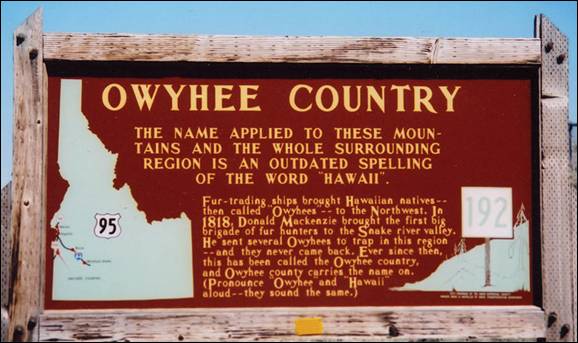
The name, Owyhee,
comes from early fur trappers. In 1819, three natives from Hawaii,
part of Donald McKenzie’s fur-trapping expedition, were sent to trap a large
stream that emptied into the Snake River. When
they did not return, McKenzie investigated and found one man murdered in camp
and no sign of the others. The stream was named in their honor. “Owyhee” is an
early spelling for the word Hawaii.
The Oregon Trail, the earliest road in the area, was used by emigrants for over
30 years on their long trip to the Oregon
country. The part of the Trail in Owyhee
County was known as the South Alternate Route
or “dry route”. The Owyhee road was shorter
but much harder than the main trail. Gold was discovered in rich placer
deposits in the Owyhee
Mountains in May, 1863. A
search for the source of the gold led to quartz ledges on War Eagle Mountain. Before the fall of 1863
several hardrock mines were being developed. Three
towns grew to supply the miner’s needs. Booneville, Ruby
City and Silver City
were the first three settlements in the county. Only Silver City
still stands, its well-preserved buildings a silent testimonial to the lively
mining days. The beautiful ruby silver ore and the wealth of gold taken from
the mountains made the mining district world famous. While Ruby City
was named the first county seat, its population and businesses soon moved to a
better location two miles upstream on February 1, 1867. Silver City
was closer to most of the mining operations and had a better winter location.
In 1934, after the decline of mining, the county government was moved to
Murphy, more central to the livestock and agricultural sections of the country.
Owyhee
County’s original boundary was the
portion of Idaho Territory
south of the Snake River and west of the Rocky Mountains. Less than a month after the creation of Owyhee County,
Oneida County was formed in January 1864 from
the eastern portion of the county. The formation of Cassia County
in 1879 took further territory in the east. The county gained its present
boundaries in 1930 after an election approved moving a portion of Owyhee County
near Glenns Ferry and King Hill to neighboring Elmore County.
In 1934 the county seat was moved from the nearly abandoned Silver City
to its present location in Murphy.
Owyhee
County’s history is inextricably
linked to the mining boom that dominated Idaho Territory
in the second half of the 19th Century. Silver
City and Ruby City
are among the state’s most noteworthy ghost towns from the period. At its
height in the 1880s, Owyhee County was among the most populous places in Idaho. Today it is among
the least populous, at 1.4 persons per square mile.
The first white men in the Owyhee country were fur trappers. They were part of the
Donald McKenzie expedition of 1818. In fact, it is this expedition that gave
the area its name. Three Hawaiian Islanders accompanying the party disappeared
while exploring the Owyhee
River. Afterwards both
the river and the entire region became known as “Owyhee”, a variation of the
word Hawaii.
Early fur traders also named another river in this high desert. The name Bruneau
River comes from the
French trappers phrase “le brun
eau” or the brown water.
The trappers were few in number and they
didn’t stay long. It was the discovery of gold that brought many more people to
the Owyhees. Idaho
was already a mecca for gold seekers by the early
1860s. As prospectors fanned out throughout the state they eventually found
their way into the Owyhee
Mountains. It was a
worthwhile trip for the group that discovered gold there in 1883. The small
stream that yielded the treasure was named Jordan Creek
after the leader of the party. Other miners quickly poured in to seek their
fortune and towns like Booneville, Ruby
City and Silver City
were born.
The strikes were rich and Silver City
and other mining towns thrived. Before long entrepreneurial
ranchers saw an opportunity in feeding the throngs of miners. Eventually
ranchers established large herds of cattle on the sage covered plateaus and
along the canyons carved by the Owyhee and Bruneau rivers. But life in the harsh desert terrain wasn’t
easy for those early pioneers. Rough-hewn log cabins miles from nowhere stand
as a testament to their challenge of the desert.
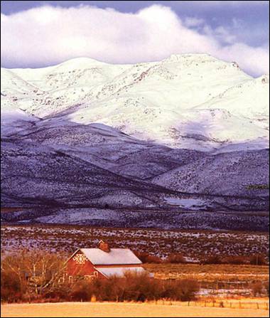
The Owyhee Canyonlands
are a vestige of the great American west. The sparsely populated high desert
located in southwestern Idaho, northern Nevada, and eastern Oregon may be the most remote area in the
lower forty-eight. It is a vast and rugged landscape of about six million
acres. The topography of the region includes rolling sagebrush steppe, plateaus
of volcanic rock, juniper covered mountains and sheer walled canyons. Most of
the area is public land administered by the Bureau of Land Management.

North Fork Owyhee River
along Owyhee Uplands Back Country Byway.
More on Owyhee
County and Idaho Byways at:
Summer in El-Wyhee
Majestic Idaho Road
Trips
Bruneau
Pierre Bruneau
discovered the Bruneau River
and Canyon in 1815, while employed by the Hudson Bay Company, as a chartographer.
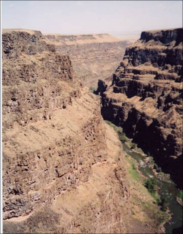
The spectacular desert gorge on the Bruneau
River is 1300 feet wide, 800
feet deep and 60 miles long with one accessible overlook from which to view the
canyon. Bighorn sheep and antelope can be seen in the area.
Pierre Bruneau
was born in 1796 at Maskinouge, Quebec
and served as a Captain in the War of 1812. He was on an assignment in Oregon, shortly after the Lewis and Clark exploration and
decided to travel on, into Idaho.
He was honored by the Hudson Bay Company, when they named his new chartered
area, in his name.
In the early 1870s approximately forty
ranchers lived in the Bruneau valley. The area was
used to grow grain, corn, lettuce, and Chinese sugar cane. The first store
opened in Bruneau in 1881.
The area was used for sheep range land, but
water was a scarcity and had to be hauled to the sheep camps. In the fall the
sheep were driven to railheads in Mountain Home and Murphy.
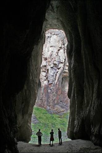
This cave draw (left) is in the Jarbidge Rivers Wilderness area located on the high basalt
plateaus of Owyhee County in southwestern Idaho.
Bruneau Dunes
State Park

The Bruneau Dunes
are unique in their formation, and are in vivid contrast to the surrounding
plateaus. Most dunes form at the edge of a natural basin; these dunes form near
the center. They include the largest single structured sand dune in North America, with a peak 470 feet above the surrounding
desert land.
The combination of a fairly constant wind
activity, a source of sand, and a natural trap have caused sand to collect in
this semicircular basin, (aka Eagle Cove) for about 15,000 years. Unlike most dunes,
these do not drift far. The prevailing winds blow from the southeast 28 percent
of the time and from the northwest 32 percent of the time, keeping the dunes
fairly stable. The two prominent dunes cover about 600 acres. So if or when you
visit please feel free to kick off your shoes while you stand atop one of these
amazing dunes, every step will be incredible!
Desert Habitat
The park contains lake, marsh, desert,
prairie and dune habitats. Since most desert wildlife is nocturnal, early morning
and late evening are the best times for spotting the park’s inhabitants.
However, a sharp eye often is rewarded with a daytime glimpse of lizards and
rabbits, or raptors such as owls, hawks and eagles. Look for tracks in the
sand, night creatures leave endless imprints creating small shadows along these
breath taking dunes. There is no hunting in the park—except with cameras and
binoculars. Motorized vehicles are not allowed on the dunes.
The Lakes
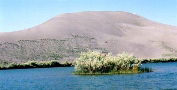
Since the 1950’s, small lakes have appeared adjacent
to the sand dunes. These small lakes
have brought additional plant life and animal life to the park area. They are
known to provide an excellent bass and bluegill fishery. The locals say it’s
one of the better fishing spots for bass. But locals warn, “Take plenty of bug
spray, for those hungry horse flies!” Sport fishing from the shore, non
motorized boats, canoes, rubber rafts and float tubes are welcomed.
The Observatory
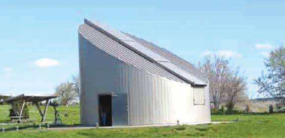
The Bruneau Dunes
Observatory invites you to reach for the stars. This public observatory is one
of the largest in the Pacific Northwest and is
perfectly positioned away from city lights and smog. Treat yourself and don’t
go another summer without setting aside one evening to take advantage of a
unique opportunity to see the night sky like you never have before. View deep
space wonders from the Obsession telescope, it opens a door into the heavens
above, leaving many who have looked through it speechless. This amazing custom
made 25 inch reflector is the main event of the evening and is housed in a
rotating observatory building. Discover those mysterious space wonders like the
rings of Saturn or man’s first steps on the moon! You will first watch a short
orientation program inside the auditorium and then just a few short steps away
survey the heavens through the observatory’s collection of telescopes. The
Natural Science Center is open to the public at dusk each Friday and Saturday
night from March thru November. You’ll spend very little and you’ll walk away
with memories to carry for a lifetime. The observatory is adjacent to the
largest sand dune. Group programs and private showings are available; please
call the park for program details. The observatory is brought to you by the
Idaho Department of Parks and Recreation, the Boise Astronomical Society,
corporate sponsors and private donors.
Grand View
The first recorded history of Grand View
began in the early 1880’s when people in search of new homesteads began
settling in the Grand View valley area. This valley was lush with tall grass
for cattle and sheep grazing. The small streams and the Snake
River brought hopeful promise of productive agriculture. Hence, it
gained the name of Grand View. To this day, agriculture - farming and ranching
- is the basic economic strength in the area. There are many family farms still
in operation. Several cattle companies run livestock on the BLM rangelands
during the summer and in their family pasture lands during the winter. There
are still a few sheep companies in the area, though those are diminishing.
The town of Grand View was established in 1888. Since
that time the town and businesses have grown and decreased! Until the bridges
were built, to access Grand View from the north, people had to take one of the
ferries that operated along the Snake River.
At one time there were entertainment halls and bars, a movie theater, a hotel
and lobby with a restaurant, three stores, a post office, a cheese factory, a
slaughter house, auto repair shops, irrigation supply center, parts stores, a
diatomaceous (silica) plant, a bank, a barber shop, and several other small
businesses. Today many of these businesses are closed and the locations of some
are no longer evident in the community.
The history of the valley is closely tied to the development of several
irrigation projects. In 1887, the Snake River Land Irrigation Company of Rhode Island began construction of the dam on the Bruneau
River to provide water
for the valley. The dam was washed out by flood water in 1890, but was rebuilt
in 1892 by the Owyhee Land and Irrigation Company, also of Rhode Island. But promoters were not able to
develop the land until the turn of the century. In 1910, the Bruneau Dam again broke and the Grand View Irrigation
District was formed to reconstruct the dam. Early promoters were also aware
that there was gold in the Snake River. In
1892, 26 placer mining claims were filed on the Snake
River in the vicinity of Grand View. By 1904, Grand View boasted
two ferries that were busy taking travelers and freighters across the Snake River. Established prior to 1894, the Hall Ferry
crossed the Snake River several miles above the mouth of the Bruneau River.
The Dorsey Ferry at first worked the Bruneau River near its mouth. After several
years it moved to the Snake River. It became
the nucleus for the town sometimes called Dorsey and later named Grand View. In
1921, the townç—´ first bridge was constructed a few
yards upstream from the Grand View Ferry.
In 1909, a third crossing, the McKeeth Ferry,
began operation six miles down river from Grand View and continued service
until 1939.
Raising hay for the many sheep companies that wintered in the valley
helped to develop the area. The Elmore Times in 1915 estimated 150,000 sheep
were fed that winter. The area was promoted for raising fruit, berries and
melons.
The years from 1910 to 1921 saw continued growth of the town with the
construction of the two-story brick bank building, a dance hall and ice cream parlour, two general stores, a saloon and pool hall. a four-room brick schoolhouse and several other businesses.
(Source: City of Grand
View)
Homedale
Homedale is the largest of the many towns
that dot the landscape of Owyhee
County. Jacob Mussell was the first known permanent settler in the area
when, in 1898, he built a ferry boat to help people cross the Snake
River.
It was just 11 years later when the official
townsite was platted, a mayor and council were put
into place, and a town name was selected by drawing names from a hat.
The region is significant in Idaho History
for many reasons. Not only is Owyhee
County the second largest
in the state, it was also the first county formed by the Idaho Territorial
Legislature in 1863.
One branch of the Oregon Trail crossed
through Owyhee County. And rich mineral deposits
brought miners high into the Owyhee Mountains to places like Silver City.
Much of Silver City is still standing and is a popular
recreational destination.
With a new town established, a two-story
brick school house soon followed in 1913. That same year the Union Pacific
Railroad built a line connecting Homedale to Nyssa, Oregon.
The railroad, coupled with irrigation, helped turn Homedale and Owyhee County
into a productive farming region.
The ground surrounding Homedale produces alfalfa
seed, sugar beets, potatoes, corn and grain. The area on the other side of the Snake River also produces hops and a bounty of wine
grapes.
Two cultures play a major part in the
community of Homedale: Basque and Austrian. A large number of people with
Austrian heritage live in an area south of the city called Austrian Town.
They were lured to Homedale in 1914 by unscrupulous land speculators who “sold”
them the ground. After making the trek to Idaho, the settlers found
that not only was the ground undeveloped, but they still had to purchase
the land from the government.
Homedale continued to grow over the years
with the first bridge spanning the Snake River
in 1921. At one time there were 15 churches serving Homedale. And even though
many people over the years have migrated to larger cities, Homedale has
continued to prosper.
The town now attracts people looking for the
quiet, comfortable and close-knit life that can be had here in rural Idaho.
Homedale is more than a small rural Idaho town; it’s a place
of quality country living. Homedale is located along the great Snake River in Southwest Idaho. Its rolling hills are tailored and
groomed with alfalfa, corn, wheat crops and Idaho’s treasured vineyards. Matching the
rolling hills are the majestic Owyhee
Mountains to the south.
The sunsets will captivate your desire for the serenity of country living and
family values. Community is the essence of Homedale which offers more than a
place to live, work and do business; it offers a way of life - like it used to
be. For more information on the City of Homedale:
http://cityofhomedale.com/.
Marsing
Marsing, known as
the Gateway to Owyhee
County, is a land of
diverse opportunity and activity. Marsing is the home
of one of the few Jet Sprint Boat race tracks in the United States. Small boats race
against time on a narrow, twisting water track. The sport provides chills,
thrill and lots of spills.
Murphy
With a population of about 50, the town of Murphy is perhaps the
nation’s smallest county seats. It is located approximately 30 miles west of
Grand View on Highway 78.
Murphy is the county seat of Owyhee County,
the second largest county in Idaho
with 7,639 square miles.
Murphy was named after Cornelius Murphy, the
crew boss on the private railroad which was being constructed by wealthy mine
owner Colonel William H. Dewey. The railroad was supposed to have extended on
to Dewey’s Owyhee mines. Because of the drop
in ore prices, construction was halted.
Murphy became the county’s only railroad
terminal and became very busy with passengers, freight and mail. The railroad
operated from 1899 until 1947 and led the Pacific
Northwest in the number of livestock shipped by rail.
In its heyday, Murphy had a lumber company,
a harness shop, restaurant, two livery barns, three saloons, two hotels, two
grocery stores and a railroad warehouse. Today, very little remains of these
buildings.
The Historical Museum
in Murphy can provide you with a very good detailed history of the area. Also,
Murphy General Store has a very good cafe!
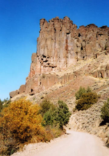
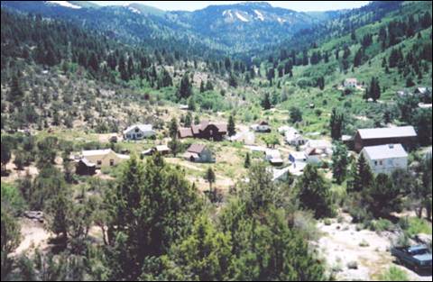
Silver City
Silver
City is a ghost town in Owyhee County, Idaho,
United States.
At its height in the 1880s it was a gold and silver mining town with a
population of around 2,500 and approximately 75 businesses. Silver City
served as county seat of Owyhee
County from 1867 to 1934.
Today, the town has about 70 standing buildings, all of which are privately
owned. Many of the owners are third- or fourth-generation descendants of the
original miners. There are a handful of small businesses, but no gas or service
stations.
Silver City at its height in the 1880s was a gold
and silver mining town with a population of around 2,500 and approximately 75
businesses.
Silver
City was founded in 1864 soon after
silver was discovered at nearby War
Eagle Mountain
(elev. 8,065 ft. The settlement grew quickly and was soon considered one of the
major cities in Idaho
Territory. The first
daily newspaper and telegraph office in Idaho
Territory were established in Silver City.
The town was also among the first places in present-day Idaho to receive electric and telephone
service.
The placer and quartz vein mines became
depleted around the time Idaho
became a state in 1890. Due in part to its extremely remote location, Silver City
began a slow decline but was never completely abandoned. Small-scale mining
continued off and on until World War II; the last mine to be operated all year
round in Silver City was the Potossi, managed by Ned
Williams. The Idaho Hotel in Silver
City was restored and
re-opened in 1972.
In 1972, the townsite
and its environs were listed on the National Register of Historic Places as a
historic district, the Silver City Historic District, with a total area of
10,240 acres.
Editor’s note: Check with Owyhee Publishing
in Homedale, Idaho
on other published materials about Owyhee
County and Silver City.
Source:
Summer in El-Wyhee, Owyhee Co. Gov., & Wikipedia.
# # #
The Elmore County Press is very pleased
to offer this link to the Owyhee Avalanche which provides news of and
throughout Owyhee County (southwest corner of Idaho).
Owyhee County News