Majestic
Idaho Road Trips
(Sponsored by Elmore County Press
& El-Wyhee Hi-Lites)
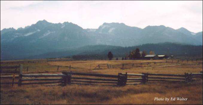
Wildlife Canyon
Scenic Byway
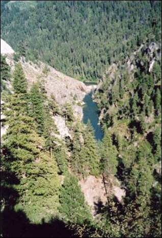
The turbulent South Fork of the Payette River Canyon
is the attraction along this route. Rafting, fishing, watching for wildlife and
soaking in hot springs
are highlights of this drive between Banks and Lowman.
Whitewater Kayaking & Rafting
On The Popular Payette
River
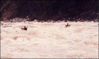
Whitewater kayaking is the sport of paddling a kayak on a moving body of
water, typically a whitewater river. Whitewater kayaking can range from simple,
carefree gently moving water, to demanding, dangerous whitewater. River rapids
are graded like ski runs according to the difficulty, danger or severity of the
rapid. Whitewater grades (or classes) range from I or 1 (the easiest) to VI or
6 (the most difficult/dangerous). Grade/Class I can be described as slightly
moving water with ripples but for that reason is not considered 'Whitewater.'
Grade/Class II/2 can be described as moving water providing some small degree
of challenge. Grade/Class VI can be described as extremely severe or almost unrunnable whitewater.

The
whitewater kayak is typically rotomoulded from a
tough plastic that is slightly flexible and very durable, if easily scratched.
Boats can range in size from barely long enough to hold the paddler (around 5 ft long (or even
smaller for children), up to 12 ft or longer.
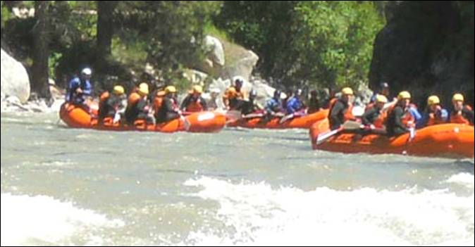
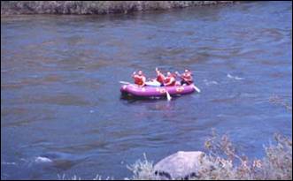
Rafting
or white water rafting is a challenging recreational activity using an
inflatable raft to navigate a river or other bodies of water. This is usually
done on white water or different degrees of rough water, in order to thrill and
excite the raft passengers. The development of this activity as a leisure sport
has become popular since the mid-1970s.
The
modern raft is an inflatable boat, consisting of very durable, multi-layered
rubberized or vinyl fabrics with several independent air chambers. The length
varies between 11 ft and 20 ft, the width between 6 ft and 8 ft. The exception
to this size rule is usually the packraft, which is
designed as a portable single-person raft and may be as small as 4.9 ft long
and weigh as little as 4 pounds. Rafts are usually propelled with ordinary
paddles and typically hold 4 to 12 persons.
An all-around
family favorite, the popular Payette
River offers every kind
of experience from placid Class I and II water to thundering Class V+.
Some have
compared the Payette and its tributaries to the public school system: the Main
Payette provides a basic education in whitewater technique; the Cabarton stretch of the North Fork is high school material;
sections of the South Fork will will earn you a
college degree in whitewater; and if you can master the daunting Class V+
waters of the North Fork below Smith’s Ferry, you’ve got yourself a Ph.D. in
whitewater rafting!
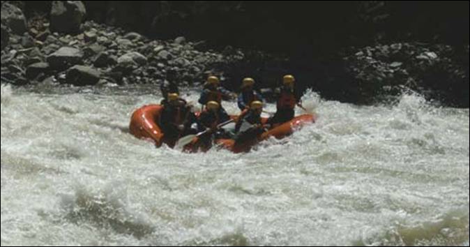
On a hot
summer day, the nine mile stretch of the Main Payette beginning at Banks will
be filled with dozens of rafters and kayakers, eager to challenge the Class III
rapids of Mike’s Hole, Mixmaster, and AMF.

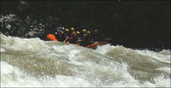
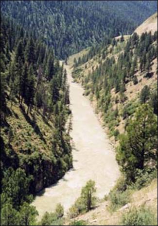
For
intermediate boaters, the Payette’s best whitewater lies in the South Fork
Canyon; there you will
find several Class IV rapids, including a mandatory portage around the 40 foot
Class VI Big Falls. You will also enjoy a wilderness experience (at least for a
few miles) complete with hot springs!

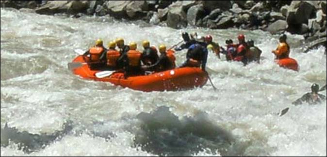
Further
downstream, near the South Fork’s confluence with the main Payette, boaters can
challenge themselves on Staircase Rapid, a long Class III – IV rapid, which has
taught many boaters the value of staying in their rafts.
On the North Fork of the Payette lies the popular Cabarton run which features a real sense of solitude, as
well as several Class III – IV rapids near the end of the run.
The North Fork below Smith’s Ferry provides 16 miles of
non-stop, Class V rapids. This stretch was first kayaked in the 1970’s and
first rafted in the late 1980’s. With a gradient of 105 feet per mile, it is
certainly understandable.
Classifications
of Rivers For White Water Rafting:
Class I: Very small rough areas, might require slight maneuvering. (Skill Level: Very
Basic)
Class II: Some rough water, maybe some
rocks, might require some maneuvering.(Skill Level:
Basic Paddling Skill)
Class III: Whitewater, small waves, maybe a
small drop, but no considerable danger. May require significant maneuvering.(Skill Level: Experienced paddling skills)
Class IV: Whitewater, medium waves, maybe
rocks, maybe a considerable drop, sharp maneuvers may
be needed. (Skill Level: Whitewater Experience)
Class V: Whitewater, large waves, large
volume, possibility of large rocks and hazards, possibility of a large drop,
requires precise maneuvering (Skill Level: Advanced Whitewater Experience)
Class VI: Class 6 rapids are considered to
be so dangerous as to be effectively unnavigable on a
reliably safe basis. Rafters can expect to encounter substantial whitewater,
huge waves, huge rocks and hazards, and/or substantial drops that will impart
severe impacts beyond the structural capacities and impact ratings of almost
all rafting equipment. Traversing a Class 6 rapid has a dramatically increased
likelihood of ending in serious injury or death compared to lesser classes.
(Skill Level: Successful completion of a Class 6 rapid without serious injury
or death is widely considered to be a matter of great luck or extreme skill)
The North Fork of the Payette parralls Highway 55 (Payette River Scenic Byway) from Banks
northward. This riverside drive takes you through Smiths Ferry, Cascade
and to the popular resort town of McCall and
shimmering Payette
Lake.
The South
Fork parallels Highway 21 (Wildlife Canyon Scenic Byway) from Banks through Garden Valley
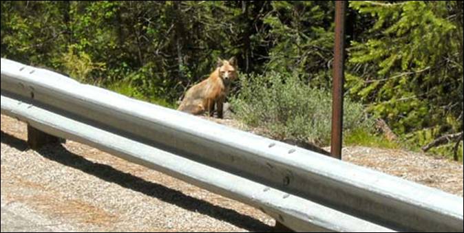
to Lowman. Rafting, fishing, watching for wildlife (like the fox pictured below)
and soaking in hot springs
are highlights of this scenic drive.
The drive
alongside the Main, North and South Fork of the Payette River
is quite beautiful, especially this time of year.
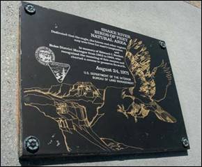
Payette River &
Black Canyon Dam
History:
In the 19th century, white settlers began moving into western Idaho and established trading posts, towns
and farms in the area. One of these early pioneers was Francois Payette, for
whom the river is named. A French-Canadian fur trapper who worked for the North
West Company, he was one of the first people of European descent to settle in
the Payette River area. Payette ventured east from Fort Astoria
in 1818. From 1835 to 1844, he headed the Hudson's
Bay Company's Fort Boise trading post near Parma,
on the Snake River some distance south of the Payette River.
In 1844, Payette retired to Montreal,
still over twenty years before emigrants began to arrive in great numbers. One
of the first settlements was on Clear Creek, a tributary of the South Fork
Payette River.
Many of the Native Americans were unhappy with the new settlers and the great
numbers of pioneers traveling through the area bound for the West Coast for
causing damage to their lands, leading to the Nez Perce War of 1877 and many
small conflicts with miners, ranchers, farmers, homesteaders, and soldiers.
Logging
in the basin began soon after the arrival of settlers, but did not reach large
scale until the early 20th century. Demand for wooden railroad ties for the
Oregon Short Line (OSL) in the 1880s helped to kick off the logging industry in
the area. From then on, heavy logging commenced along the North
Fork Payette River in Long
Valley, downriver of present-day Cascade Lake. A splash dam was built in 1902 by
the Minnesota-based Payette Lumber and Manufacturing Company on the North Fork in order to better facilitate the
transportation of logs downstream. Logging helped to spur even more people to
move into the area, and in 1911, the Idaho Northern Railroad was constructed by
the OSL, running from Emmett near the mouth of the Payette along the river,
past present-day Black Canyon Reservoir, up into the North Fork watershed and
ending in Long Valley at Smith's Ferry on the river, named for a settler who
bought the operation in 1891. The ferry's primary purpose was to transport
livestock and agricultural products between Long
Valley and the Snake
River.
Agriculture, however, became the primary mainstay in the lower valley of
the Payette River. Following from 1874, irrigated
farmland surrounded much of the main stem of the Payette River.
The Last Chance
Canal and Nobel Canal
were among the first irrigation ditches constructed, but did not provide a firm
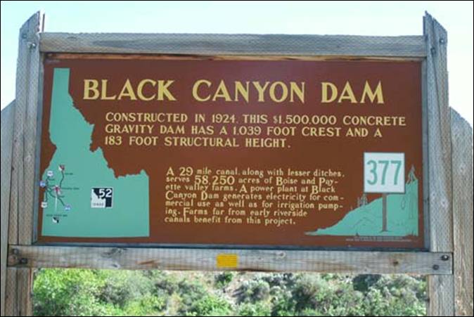
yield because of the lack of water regulation. Black Canyon Dam was constructed
on the Payette in 1824 not as a storage facility, but to divert water into the
Emmett and Black Canyon Canals,
which vastly increased the irrigated acreage in the valley. Deadwood Dam on the
Deadwood River,
a tributary of the South Fork Payette
River, was built in 1929 to provide
some degree of flow regulation, though much more effective was the Cascade Dam,
constructed on the North Fork in 1948 to form Cascade Lake.
Payette River
The Payette River
is a 62-mile river in southwestern Idaho, and
is a major tributary of the Snake River.
Its
headwaters originate in the Sawtooth and Salmon River mountains at elevations over 10,000 feet.
Including the North Fork Payette River,
the drainage flows in a westerly direction for over 175 miles, while with the
South Fork, the cumulative length exceeds 182 miles, through an agricultural
valley then empties into the Snake River near the city of Payette at an elevation of 2,125 feet. The Payette River's drainage basin comprises about
3,240 square miles. It is a physiographic section of the Columbia Plateau
province, which in turn is part of the larger Intermontane
Plateaus physiographic division. The South Fork of the Payette has its
headwaters in the Sawtooth Wilderness, which is part
of the Sawtooth National Recreation Area.
The
river's watershed was originally settled by the Shoshone, Nez Perce, Paiute and
Bannock Native American tribes. Before white contact, many of these indigenous
peoples had no permanent villages or settlements. For hundreds of years, in the
fall and winter, they would camp in the arid grasslands along the main stem of
the Payette River,
while in spring and summer, they temporarily moved to the lusher
upper basin of the North Fork to hunt and fish
in preparation for the coming winter. Camas bulbs, coming
from a widespread flowering plant in the basin, was their primary staple
throughout the year. In order to maintain the naturally occurring fields of
camas, they would set controlled fires whenever they left their camps for the
biyearly move through the river basin. The seasonal burning came with added
benefits, including clearing unwanted vegetation and protecting their campsites
from overgrowth.
Due to
the wide range in elevation, the Payette
River has a variety of
fish and fish habitats. Salmon and steelhead were eliminated in the drainage by
Black Canyon Dam, which was first completed in 1924. From its mouth upstream to
Black Canyon Dam, the river supports a mixed fishery for coldwater and warmwater species. Mountain whitefish make up the bulk of
game fish in this section of river, with smallmouth bass, largemouth bass,
channel catfish, black crappie, rainbow trout, and brown trout making
significant contributions. Upstream from Black Canyon Dam, the gradient of the
river increases with coldwater species increasing in abundance. The South Fork
of the Payette River supports excellent populations of
wild rainbow trout. The North Fork of the Payette River
has been severely altered by railroad and highway construction and provides
only a marginal fishery for salmonids. However, in
unaltered sections such as the Cabarton reach, the North Fork is very productive for salmonids.
There are
five major impoundments in the Payette basin: Black Canyon,
Sage Hen, Paddock, Cascade, and Deadwood reservoirs. There are also several
small impoundments and natural lakes with increased storage, such as the three Payette Lakes. Black Canyon,
on the mainstem, provides only marginal fish habitat.
Sand from upstream land disturbances has covered most of the habitat. Paddock
Reservoir, on Big Willow Creek, has one of the better populations of black
crappie in the state and a good fishery for largemouth bass. Cascade Reservoir
on the North Fork is one of the most heavily
fished waters in the state. Cascade has an abundance of yellow perch, coho salmon, and rainbow trout. Deadwood Reservoir,
completed in 1931, contains kokanee and cutthroat
trout.
Alpine
lakes within the Payette
River drainage are
stocked with rainbow trout, cutthroat trout, cutbow
(rainbow-cutthroat hybrids), golden trout, and arctic grayling. Brook trout are
also present in a number of lakes.
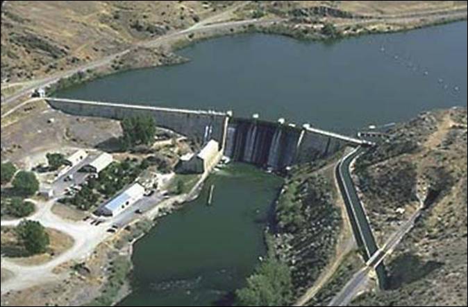
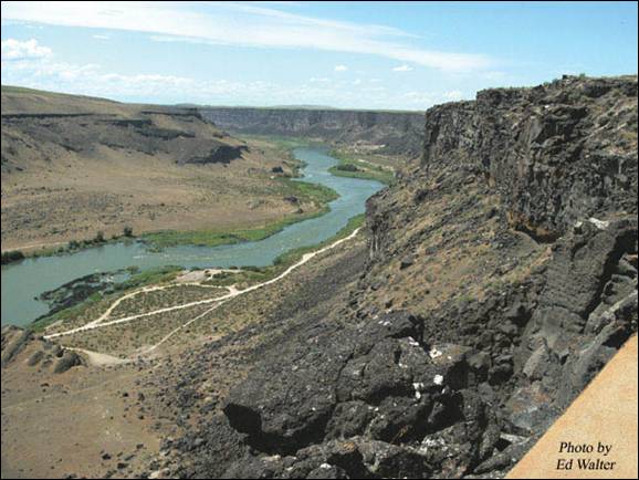
Black Canyon Reservoir
Black Canyon Reservoir, near Emmett, is
formed by Black Canyon Diversion Dam and managed by the Bureau of Reclamation. This
1,100-acre reservoir offers 12 miles of shoreline; boating and fishing are the
major recreational activities. Anglers fish for largemouth bass, rainbow trout,
crappie, white fish, bullhead and channel catfish. The canyon sits amid the
gently rolling prairie between Emmett and Horseshoe Bend. The area is a know
winter feeding ground for deer and elk. Its remote location provides ample
animal and bird watching opportunities. Come and enjoy the quiet solitude this
scenic location offers.
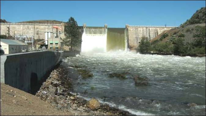
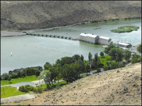
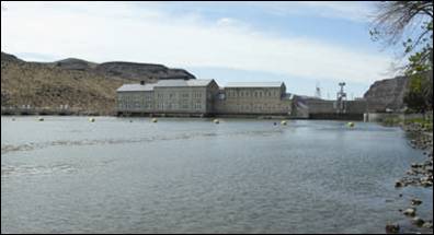
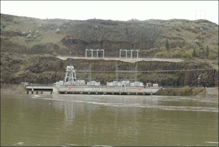
Black Canyon Diversion Dam, on the Payette River
near Emmett, Idaho, is a concrete gravity type dam with
an ogee overflow spillway. The dam has a structural height of 183 feet and
serves to divert water to the Payette Division through Black Canyon
Canal. The original
capacity was 44,700 acre-feet but heavy siltation has reduced the capacity. At
full pool there is now a volume of 29,600 acre-feet. Water is diverted at Black
Canyon Diversion Dam by gravity into the Black
Canyon Main
Canal on the south side of the Payette River
and by two direct connected turbine-driven pumps, located in the powerhouse, to
serve the Emmett Irrigation District
Canal on the north side
of the river. The two unit powerplant had an initial
total capacity of 8,000 kilowatts. The unit’s electrical components were
upgraded to 5,100 kilowatts each in 1995 to provide the capability of
generating 10,200 kilowatts with further upgrade of the turbines. Present
generating capacity however, is limited to about 10,000 kilowatts. The plant
supplies power to the Southern Idaho Federal Power System for Bureau of
Reclamation project uses and for non-project purposes.
In 1988, a six-inch raise in Black Canyon
Reservoir water surface was implemented by modifying the spillway drumgate and the radial gate at the Black Canyon
Main Canal
headworks. This was done to improve regulation of
irrigation diversions from Black Canyon Reservoir to the Black Canyon
Main Canal
and to conserve the amount of stored water released from upstream reservoirs to
meet fluctuating irrigation demands.
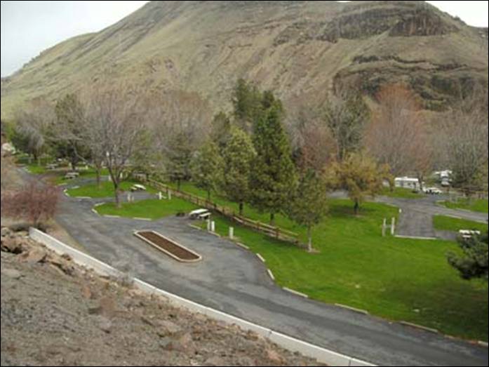
There are three day-use parks located at or
near Black Canyon Dam — Black Canyon Park,
Wild Rose Park, and Cobblestone
Park. Triangle Park
offers both day-use and overnight camping.
There is a $5 per car daily fee at Black Canyon
Park. Newly issued season
passes are available for $25. Previously issued season passes can be renewed
for $20. You must swipe your electronic season pass at the card reader each
time you enter or exit the park. If you do not swipe your card when you exit
the park, you will need to contact Reclamation staff to have it reset.
Triangle
Park, located just upstream of Black Canyon
Park, is available for
group overnight camping for a fee of $125.00. Water and power are not available
at this park.
Gazebos at Black Canyon
Park and Wild Rose Park
can be rented for a daily non-refundable fee of $125.00. Only the gazebos can
be rented, not the entire park. The shelter at Cobblestone Park
can be rented for a daily non-refundable fee of $125.00.
Montour
Park, located in the
Montour Wildlife Management Area, has overnight camping at $8.00 a day. There
are 18 spaces which are available on a first-come, first-serve basis. Potable
water and bathrooms are available.
_____________________________________________________
Sawtooth
Scenic Byway
Climb 115 miles up Highway 93 and 75 into
the heart of central Idaho, from the high
desert to the Sawtooth
Mountains at Stanley. Highlights include Sun Valley Ski
Resort (founded in 1936), Galena Summit, and Redfish Lake.
Sawtooth
Mountains Near Stanley
The Sawtooth
Scenic Byway has the distinction of being the 100th National Forest
Scenic Byway. Beginning in Shoshone, the southern leg of the byway features the
new Black Magic Canyon geological attraction. The route then
rolls north through fertile agricultural land to the resort towns of Hailey,
Ketchum, and Sun Valley.
From there, the road carves its way through
the Boulder Mountains
to Galena Pass,
showcasing the ridge of the Sawtooth Mountains.
Beyond, the rocks and woodlands of the rugged Sawtooth
National Recreation Area are packed with rivers, streams, and 300 alpine lakes,
providing top-notch venues for a variety of year-round activities. Wildlife
watchers should stay alert; the 756,000-acre recreational area is home to many
species of wildlife, including pronghorn antelope, deer, elk, bear and wolves.
The northern tip of the byway terminates in Stanley, where the Sawtooth meets the Ponderosa Pine and Salmon River Scenic
Byways. So no matter which way you drive in or out, you’re in for a treat.
Western Heritage Historic
Byway
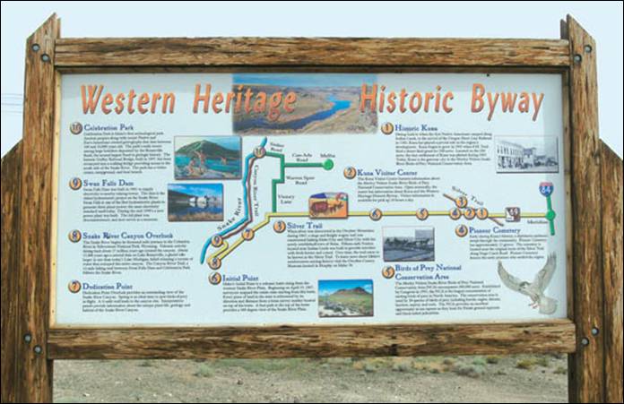
Wagons loaded with gold mined in the Owyhee Mountains
took this route to Fort Boise over desert trails and across the Snake River. Today it includes southern Idaho
farmland, the rugged Snake River
Canyon, Swan Falls Dam
and the Snake River Birds of Prey National Conservation Area.
When President Lincoln turned his attention
from the Civil War to proclaim Idaho a U.S.
Territory, migration south from Fort
Boise had already begun.
Huge silver and gold discoveries had been made in the Owyhees.
Emigrants trudged trails south and twenty-horse teams moved mine machinery over
rattlesnake-infested volcanic rifts and down the steep sides of the Snake River Canyon.
Today, where trails once existed, a broad
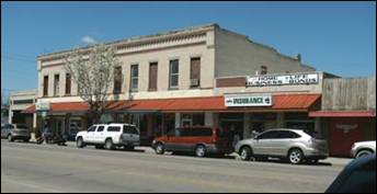
new highway passes through farmlands to Indian Creek and the town of Kuna. This historic place
was first an Indian crossing— then a traveler’s way-station—then the Shortline railhead, and finally, the growing farm community
it is today.
Kuna is the Gateway City
to the Birds of Prey National Habitat Area and is the forefront of the Western
Heritage Byways Project.
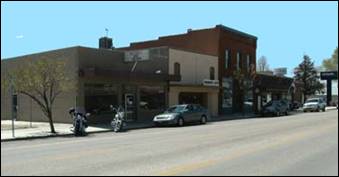
Historic Kuna, Idaho
First Pioneer Settlement along the Silver
Trail - The year was 1881 when 100 laborers arrived to build the westward
portion of the Oregon
short Line Railroad. With an Indian language dictionary in hand, E.P. Vining of the Union Pacific Railroad named the location
“Kuna” from what is believed to be a Shoshone word.
The first train arrived in Kuna in 1883.
Kuna became the valley’s transportation hub shipping goods to Boise
and Silver City
in the Owyhee Mountains along the old stage route
known today as the Silver Trail.
Four years later in 1887, rail service
arrived in Boise.
Kuna’s depot closed, and the tiny settlement vanished. The first breath of life
was given to Kuna when in November of 1903 Fremont H. Teed, an early settler
from Iowa
applied for the Desert Land Grant. With $50 in hand as the initial payment,
Teed acquired 200 acres which included the dusty remains of old town Kuna.
Kuna once again began to thrive as F. H.
Teed and D. R. Hubbard worked tirelessly to encourage settlement. Kuna’s town
folks celebrated on February 22, 1909 when the first irrigation water flowed-giving
life to 50,000 acres of new farmland.
Today, Kuna holds strong to its pioneer
heritage-a heritage built upon the early settlers who pushed back the sagebrush
covered desert to build a thriving community.
The growth Kuna has experienced the last
several years extends its boundaries to just 4 miles from the city limits of Boise. Kuna is a community
of approximately 16,100 residents, rooted as an agricultural area that is a
rapidly growing progressive community, supported by an active Chamber of
Commerce, a sense of community pride, and a high level of citizen involvement.
Kuna prides itself in good schools, responsive businesses, and fine churches.
The city is proud of its heritage, and past accomplishments.
Kuna Chamber of Commerce.
I would like to mention that this great road
trip started after a fantastic lunch at Pizza
Hut, located at 251 Avenue D in Kuna.


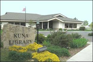
Kuna
Visitor Center
The Kuna
Visitor Center
features information about the Morley Nelson Snake River Birds of Prey National
Conservation Area. Open seasonally, the center has information about Kuna and
the Western Heritage Historic Byway. Visitor information is available for pick
up 24 hours a day.
Colonel Bernard Fisher Veteran's Memorial Park
In the city center is Colonel Bernard Fisher
Veteran's Memorial Park, named after one of the city's most famous residents.
Bernard Francis "Bernie" Fisher (born January 11, 1927) is a retired
United States Air Force officer and a recipient of the U.S. military's highest decoration,
the Medal of Honor. He was the first living Air Force recipient of the medal
(all previous awards to USAF personnel had been posthumous), and the first USAF
member to receive the medal in the Vietnam War.

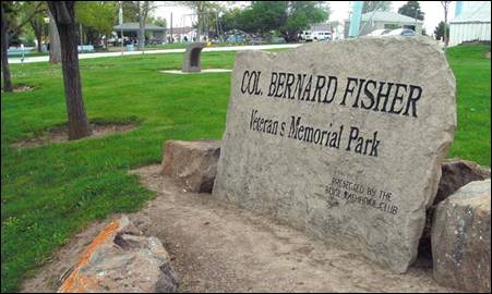
The Kuna Farmers Market is held at the
Colonel Bernard Fisher Veteran's Memorial Park from the first Saturday in May 7
(9 a.m. to noon every Saturday) through Oct. 1.
From Kuna, the byway turns south down Swan Falls Road.
Just a few miles past Kuna, the scene moves abruptly from gold and green fields
stitched together by silver irrigation canals, to rugged terrain unchanged
since wild horse herds roamed and the great hoards of jack rabbits made
settlers lives miserable.
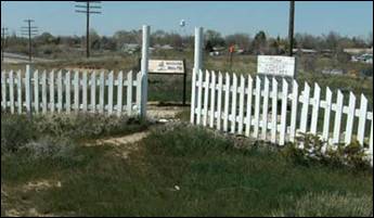
Pioneer Cemetery
Pioneer
Cemetery is all that
remains of Ten Mile community, a tiny pioneer settlement. The year was 1863;
President Lincoln signed the act organizing Idaho
Territory establishing the capital at Lewiston. That same year,
with the discovery of gold in the Owyhee
Mountains, a stage and freight wagon
route soon followed hauling supplies between Silver
City in the Owyhee
Mountains and Boise.
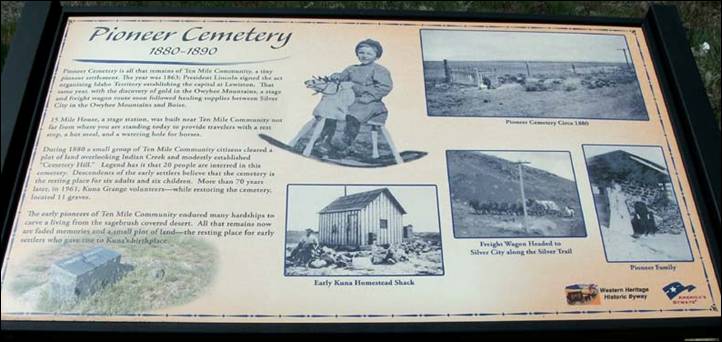
During 1880 a small group of Ten Mile Community
citizens cleared a plot of land overlooking Indian Creek and modestly
established “Cemetery Hill.” Legend has it that 20 people are interred in this
cemetery. Early during Kuna's history, a diphtheria epidemic swept through the
community. Descendents of the early settlers believe that the cemetery is the
resting place for six adults and six children. More than70 years later, in
1961, Kuna Grange volunteers-while restoring the cemetery, located 11 graves.
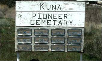
The cemetery is
located near the original route of the Silver Trail along Stage Coach Road. Pioneer Cemetery
honors the early pioneers who settled the region.
The early pioneers of Ten Mile Community
endured many hardships to carve a living from the sagebrush covered desert. All
that remains now are faded memories and a small plot of land-the resting place
for early settlers who gave rise to Kuna’s birthplace.
15 Mile House, a stage station, was built
near Ten Mile Community to provide travelers with a rest stop, a hot meal, and
a watering hole for horses.
Silver Trail
When silver was discovered in the Owyhee Mountains
during 1863, a stage and freight wagon trail was constructed linking Idaho City
and Silver City
with the newly established town of Boise.
Fifteen-mile Station located near Indian Creek was built to provide travelers
with fresh horses and a meal. Over time, the trail came to be known as the
Silver Trail. To learn more about Idaho's
southwestern mining history visit the Owyhee
County Museum
located in Murphy on Idaho
78.
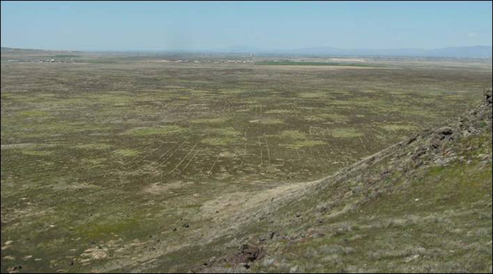
Initial Point
Initial Point looms out to the desert and
presents panoramic views of the Owyhee
Mountains and Boise
Front. A one-mile gravel road connects to the base of the butte. A short walk
up the rocky steep access trail brings visitors to an observation deck.
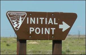
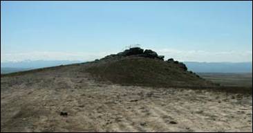
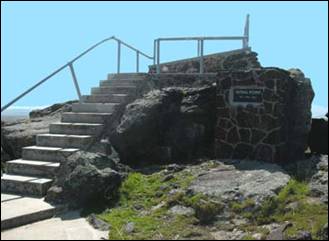
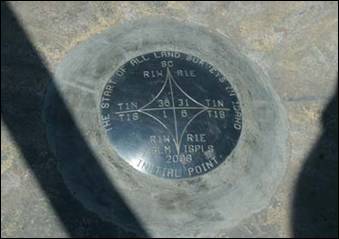
Established
in 1867, a US Geological
Survey brass marker on the top of this prominent lava butte is the starting
survey point in the State of Idaho.
The view from the top is astounding.
Snake River
Birds of Prey National Conservation Area
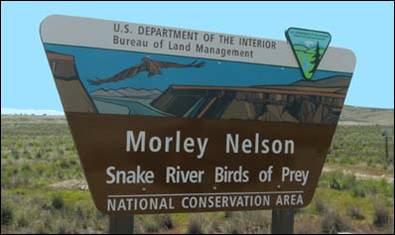
The Morley
Nelson Snake River Birds of Prey National Conservation Area (NCA) encompasses
600,000 acres. Established by Congress in 1993, the NCA is the largest
concentration of nesting birds of prey in North America.
The conservation area is used by 24 species of birds of prey including hawks,
eagles, falcons, harriers, osprey, and owls. The NCA provides an excellent
opportunity to see raptors as they hunt for Paiute ground squirrels and
black-tailed jackrabbits.
Snake River
Canyon
Overlook
The Snake
River begins its thousand mile journey to the Columbia River in Yellowstone National Park, Wyoming. Volcanic activity dating back about
17 million years ago created the canyon. About 15,000 years ago a natural dam
on Lake Bonneville,
a glacial lake larger in size than today's Lake Michigan,
failed releasing a torrent of water that reshaped the entire canyon. The Canyon
River Trail, a 12-mile hiking trail between Swan Falls Dam and Celebration Park
follows the Snake River.
Dedication Point
This scenic point provides a spectacular overview of the Snake River Canyon with an excellent view of birds
of prey in action. There is a quarter-mile trail with interpretive signs
providing insightful information about birds, geology and wildlife. Located
south of Kuna on Swan Falls Road
Swan Falls Dam
Swan Falls Dam
is on the Snake River about 40 miles south of Boise. Built in 1901 to provide electricity
to nearby (Silver City) mines, it is a historical point of interest
because it’s the oldest hydroelectric generating site on the Snake
River.
A new power
plant was built in the mid-1990s. The old plant was decommissioned and
converted into a historical display. Tours
of the facilities may be available by appointment only by calling 208-736-3458.
Swan Falls
lies within the Snake River Birds of Prey National Conservation area and is
home to falcons, eagles, owls, and hawks to name a few.
No overnight
camping facilities are available within the park but there are multiple free
camping areas above and below the dam. No water is available at these sites and
there are restrooms available only at the day-use park along with a picnic area
and portage trail around the dam for boaters. Below the dam is a ramp for
whitewater boater access to the river. Above the dam waterskiing, fishing and
duck hunting are popular seasonal activities.
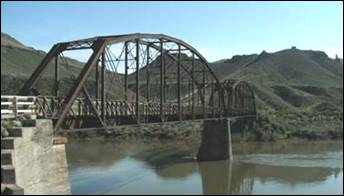
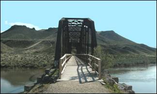
Guffey Railroad Bridge
The historic Guffey Railroad
Bridge, built in 1897, has been
revamped into a walking bridge providing access to the south side of the Snake River. The park has a visitor center, campground,
and boat launch.
The Guffey Bridge
is the only Parker-Through-Truss Railroad Bridge
in Idaho. It
was designed to facilitate the hauling of gold and silver ore from Silver City
mines at the turn of the century. The 450-ton steel structure is 70 feet tall
and spans 500 feet over the Snake River. The
bridge was abandoned in 1947, saved from demolition in the1970s and purchased
and restored by Canyon
County in 1989.
The historic Guffey Railroad
Bridge, built in 1897, has been
revamped into a walking bridge providing access to the south side of the Snake River.
Guffey, Idaho
Guffey was established
in 1897 at the railroad bridge across the Snake River.
The first building was built there on 27 May 1897.
In 1898, Guffey
had a population of over 100 and several businesses including a general store,
express office, post office, hotel, saloon, blacksmith shop, livery stables,
stage barns, boarding houses, etc.
The town was the terminus for the Boise, Nampa & Owyhee
Railroad. The railroad was planned to extend to Dewey, in the mining district
near Silver City, but it was never completed. It was
extended to the present site of Murphy, however, which caused the town of Guffey
to pass out of existence.
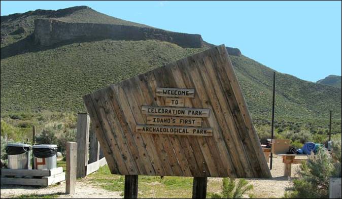
Celebration
Park
Celebration Park
is Idaho's
first archeological park. Ancient peoples along with recent Native and
Euro-Americans created petroglyphs that date between
100 and 10,000 years old.
The park's
trails weave among large boulders deposited by the Bonneville flood, the second
largest flood in geologic history. The park has a visitor center, campground,
and boat launch.
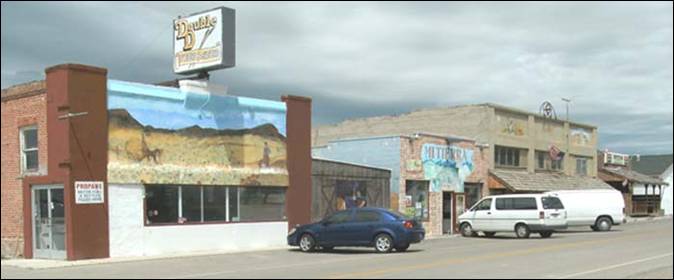
Melba,
Idaho
Nestled in the center of
the byway is the small town of Melba.
It is not a part of the main byway, but well worth the little side trip. There
are several historic buildings and fascinating murals.
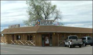
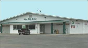
Buck's Saloon & Steakhouse Melba Valley
Market
Melba was founded in 1912 by Clayton C. Todd. He named it after
his four-year-old daughter.
According to the information from the Melba
website (http://www.cityofmelba.org/),
Clayton C. Todd was passing through the area on his
way to Alaska
to search for gold. He stopped over in Weiser to visit a friend, Mr. Fuller.
Fuller told him about the new sale of state land going on. So, in August of
1912, Mr. Todd purchased 160 acres of land at Rock Spur, a siding on the
railroad, and laid out the town.
Melba is surrounded by vast agricultural
lands growing a diverse variety of crops which include potatoes, beans, sugar
beets, onions, corn and grain. Known as The Seed Heart of America, Melba area
farmers excel in growing seeds crops for onions, carrots, peas, beans and sweet
corn seed as well as alfalfa and clover.
Article and
photos by Ed Walter.
Source of information: Idaho Scenic, Historic and Back Country
Byways; Wikipedia, Kuna Chamber of Commerce, and Melba Chamber of Commerce.
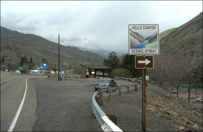
Hells Canyon Scenic
Byway - A Majestic Trip Along North America’s Deepest
River Gorge
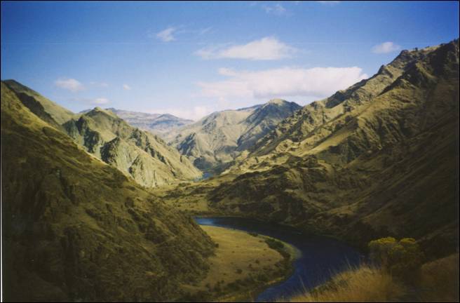
Hells Canyon
is a 10-mile wide canyon located along the border of eastern Oregon
and western Idaho.
It is North America’s deepest river gorge at
7,993 feet and part of the Hells Canyon National Recreation Area.
The
canyon was carved by the waters of the Snake River, which flows more than 1
mile below the canyon’s west rim on the Oregon
side and 8,000 feet below the peaks of Idaho’s
Seven Devils Mountains
range to the east. Most of the area is inaccessible by road.
The
earliest known settlers in Hells Canyon were
the Nez Percé tribe. Others tribes visiting the area
were the Shoshone-Bannock, Northern Paiute and Cayuse Indians. The mild
winters, and ample plant and wildlife attracted human habitation. Pictographs
and petroglyphs on the walls of the canyon are a
record of the Indian settlements.
In 1806,
three members of the Lewis and Clark Expedition entered the Hells Canyon region
along the Salmon River. They turned back
without seeing the deep parts of the canyon. It was not until 1811 that the
Wilson Price Hunt expedition explored Hells Canyon while seeking a shortcut to
the Columbia River. Hunger and cold forced
them to turn back, as did many explorers who were defeated by the canyon’s
inaccessibility. There remains no evidence in the canyon of their attempts;
their expedition journals are the only documentation.
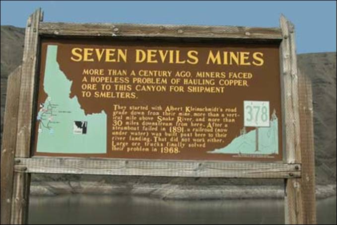
The
early miners were next to follow. In the 1860s gold was discovered in river
bars near present-day Hells Canyon National Recreation Area, and miners soon
penetrated Hells Canyon. Gold mining was not
profitable here. Evidence of their endeavors remains visible along the corridor
of the Snake River. Later efforts concentrated
on hard-rock mining, requiring complex facilities. Evidence of these
developments is visible today, especially near the mouth of the Imnaha
River.
In the
1880s there was a short-lived homesteading boom, but the weather was unsuited
to farming and ranching, and settlers soon gave up. However, some ranchers
still operate within the boundaries of the National Recreation Area.
After
completion of large hydropower dams on the Columbia River in the 1930s through
the 1950s, several entities sought approval from the Federal Power Commission
to build dams on the Snake River, including a high dam in Hells
Canyon.
The
Hells Canyon Scenic Byway winds its way along the east side of this massive
rift that separates Idaho from neighboring Oregon. According to Nez
Perce folklore, Coyote dug Hells Canyon with a big stick to protect ancestors
in Oregon’s Blue Mountains from the Seven Devils
mountain range across the gorge in what is now Idaho. Geologists believe that Hells Canyon
was formed by normal stream erosion as the Snake River
cut its way through rocks of a rising mountain range, beginning 6 million years
ago. It is still being cut and is probably deeper and more rugged today than at
any other time in its history. The 652,488-acre Hells Canyon National
Recreation Area, (designated in 1975), encompasses a 71-mile stretch of the Snake River and contains some of the country’s most unique
scenery, plants, wildlife and geology. Relatively mild winters and abundant
deer, elk, and bighorn sheep drew native peoples to the canyon; signs of human
habitation date back over 11,000 years. Pictographs and petroglyphs,
as well as winter pithouse villages, are scattered
along the river, documenting the presence of those early inhabitants.
The
Hells Canyon Scenic Byway from Cambridge to the Hells Canyon Creek Visitors
Center is approximately
51 miles.
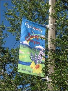
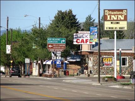
Cambridge is a small farming, ranching, and logging
community situated in a sheltered valley approximately 100 miles northwest of Boise, Idaho
on U.S. Highway 95. The community was founded in 1900 following the
construction of the Pacific and Idaho Northern Railway’s line enroute to the mining and logging fields further to the
north. The population of Cambridge
is around 360 inside the city limits.
The
elevation of Cambridge is 2,650 feet above sea
level with the surrounding mountains reaching elevations around 8000 feet,
plummeting to around 1500 feet in Hells Canyon.
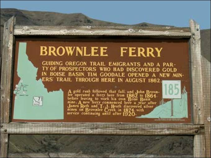
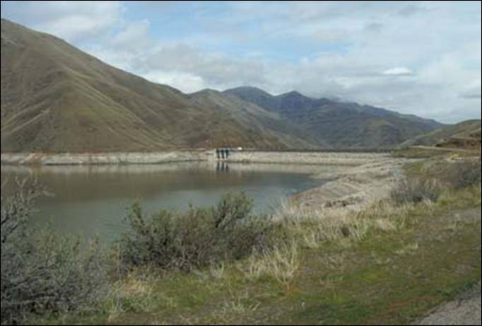
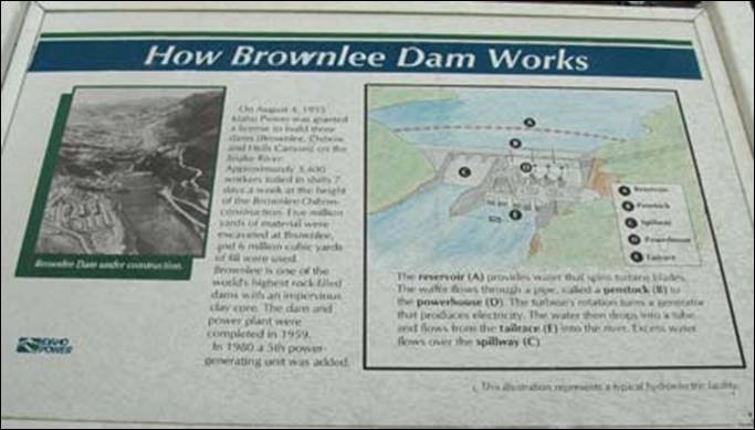
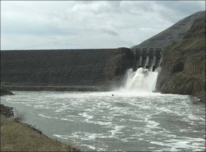
Brownlee dam is a hydroelectric
earth fill embankment dam on the Snake River on the Idaho/Oregon border, in Hells Canyon. It impounds the Snake
River in the 58-mile long Brownlee Reservoir. It is part of the
Hells Canyon Project that also includes Hells Canyon
Dam and Oxbow dam, built and operated by Idaho Power Company. The dam’s
powerhouse contains five generating units with a total nameplate capacity of
584.4 megawatts.
Located
about 20 miles northwest of Cambridge on Highway 71 is Brownlee Dam, a
hydroelectric earth fill embankment dam on the Snake River on the Idaho-Oregon
border, in Hells Canyon. It impounds the Snake River in the 58-mile long Brownlee Reservoir. It is
part of the Hells Canyon Project that also includes Hells Canyon Dam and Oxbow
Dam, built and operated by Idaho Power Company. The dam’s powerhouse contains
five generating units with a total nameplate capacity of 585.4 megawatts.
From
Brownlee Dam the byway takes you across the Snake River into Oregon
and down along the Snake River to Oxbow
Village.
Oxbow Village
(Baker County, Oregon)
is just south of the site of the former mining town of Copperfield. There was once a station named
Oxbow on a portion of the Oregon Short Line Railroad now inundated by Oxbow
Reservoir. It was named for The Oxbow, a U-shaped bend in the Snake
River named for the agricultural implement. The present-day
community of Oxbow was established in the early 1960s near the former site of Copperfield, Oregon’s
most notorious “Bad” town.
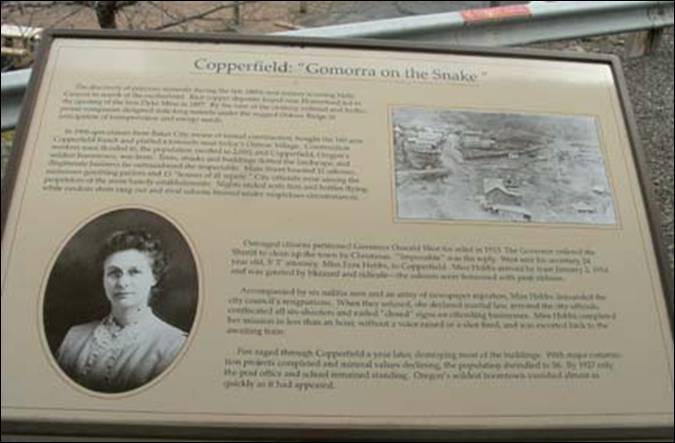
According to the historian Lewis McArthur, Copperfield
was formed in the late 1890s as "Copper Camp", and was inhabited by
prospectors of the local copper ore; However, the Oregon writer Stewart
Holbrook asserted that "there was no copper in Copperfield", and that
the community "had one purpose; namely, to cater to the uninhibited
appetites of more than two thousand men who were engaged on two nearby
construction projects."
Copperfield was platted
around 1898, along a Northwest Railway Company line that never developed.
Soon the locality was known as "Copperfield" and a post office
established in 1899. The population grew to 1,000 by 1910 because two tunnels
were being dug near The Oxbow by the local railroad company and by the
predecessor of the Idaho Power Company. This railroad activity was described as
a "brawling railroad construction camp" during this period by Barbara
Ruth Bailey.
As Holbrook describes it, "early in
1913 the construction jobs began to peter out. Fewer men were employed.
Competition for the remaining trade became stiff. The saloon keepers began
feuding." With stories of arson, the town acquired a reputation for being
lawless. When the county authorities failed to get control of the situation,
Governor Oswald West sent his secretary, Fern Hobbs, with a signed declaration of martial
law to clean up the place. A few months after Hobbs' intervention, a
fire "of unknown origin destroyed a block or two of the jerry-built
structures. No saloon ever reopened."
There were two more fires, and then the post
office closed in 1927, essentially turning Copperfield into a ghost town. In
1965, however, the community of Oxbow was founded just south of the site of
Copperfield when the Idaho
Power Company was building the Oxbow Dam. The former site of Copperfield is now
a park run by Idaho
Power.
Fern Hobbs (May 8, 1883–April 10, 1964) was an American
attorney in the U.S. state
of Oregon,
and a private secretary to Oregon Governor Oswald West. She was noted for her
ambition and several accomplishments as a young woman, and became the
highest-paid woman in public service in America in her mid-twenties.
Hobbs
made international news when Governor West sent her to implement martial law in
the small Eastern Oregon town of Copperfield.
The event was considered a strategic coup for West, establishing the State's
authority over a remote rural community and cementing his reputation as a
proponent of prohibition.
Hobbs
later worked for the American Red Cross in Europe and at the Oregon Journal newspaper. She died in Portland in 1964.
Oxbow Power Plant
From Oxbow Village
you continue on across the bridge back into Idaho
where the byway takes you on down the Snake River to Hells Canyon Dam and Hells Canyon Creek Visitor
Center.
Along
the way you will see a sign marking the remains of Big Bar and the Fruit
Merchants of Hells Canyon.
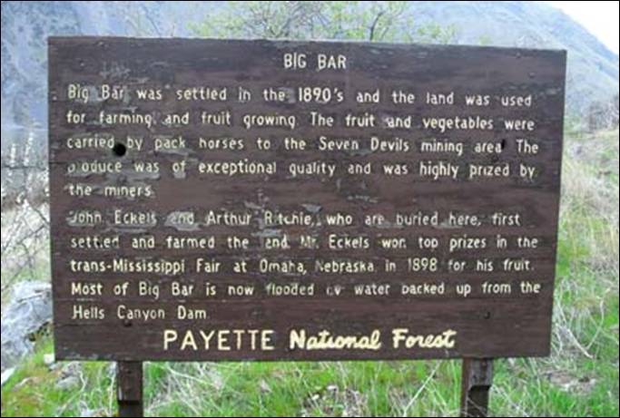
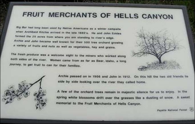
Big Bar was
settled in the 1890’s and the land was used for farming and fruit growing. The
fruit and vegetables were carried by pack horses to the Seven Devils mining
area.
John Eckels and Archibald Ritchie first settled and farmed the
area. Their grave sites overlook the area they called home, 25 acres and over
500 tree orchard. Most of Big Bar is now flooded by
the backwaters of Hells Canyon Reservoir.

Hells Canyon dam was the last of three dams of the Hells Canyon Project to be constructed. With two of its
three units, it began generating electricity in 1967. The third unit was put
into full power production in 1968, for a total nameplate capacity of 391,500
kilowatts, or 391.5 megawatts (MW). The height of this concrete dam is 328
feet.
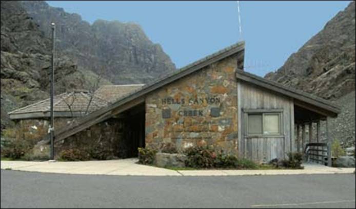
Located below Hells
Canyon Dam, the Hells Canyon
Creek Visitor
Center which has indoor
interpretive exhibits and programs, is open seasonally
from Spring through late Summer; however the outdoor displays are available
year-round. The visitor center and Hells Canyon
Boat Launch are managed in partnership with Idaho Power Corporation.

Above and below are the photos I took of the canyon down river
past the Hells Canyon
Creek Visitor
Center.
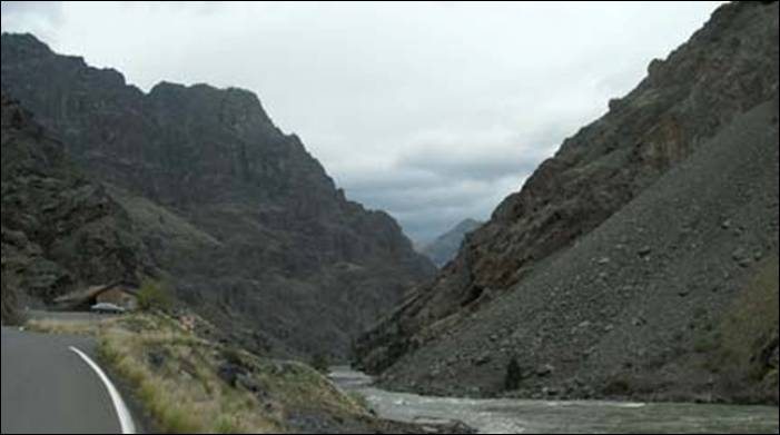
The sights
along the way are spectacular and trying to make it only a one-day-trip was
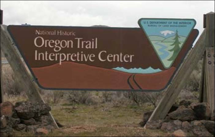
very hard. A friend of mine told me to check out the National Historic
Oregon Trail Interpretive
Center.
Taking Oregon Route 86
back at Oxbow Village
will put you on Oregon’s
Hells Canyon Byway.
There
are many sights to take in along this route, unfortunately time was not on my
side so it was pretty much a direct trip into Baker City
and then back to Mountain Home.
The National Historic Oregon Trail
Interpretive Center
was closed and almost everything else of interest was as well.
This 23,000 square-foot
interpretive center atop Flagstaff Hill overlooks nearly seven miles of
well-preserved Oregon Trail ruts that extend
across Virtue Flat southeast of Flagstaff Hill. This arid trail segment, where
emigrants fought their way through shoulder-tall sagebrush, tested weary
emigrants who had endured four or five difficult days ascending Burnt River.
In places, several ruts run parallel, suggesting some teams pulled alongside or
ahead of others in the push to reach the Powder River.
But travelers were also
greeted with their first site of the Promised Land beyond. From atop Flagstaff
Hill, the Blue Mountains beckoned in the distance, assuring emigrants that
their long journey from the Missouri would
soon end in the long awaited Willamette
Valley.
The Bureau of Land
Management operates the interpretive center. Living history programs,
life-sized dioramas, an amphitheater, and an interpretive trail system support
the center's theme of describing life along the trail.
I did
make it to Sumpter Junction Restaurant, home to the
“World Famous Operating Train” which runs throughout the restaurant.
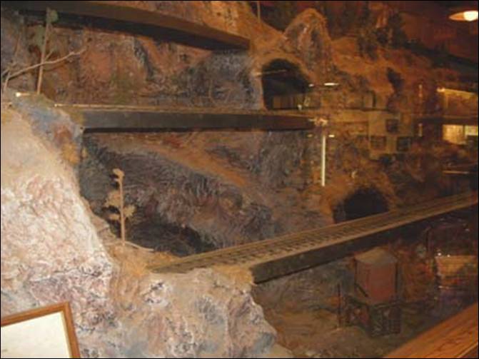
The food
and service was excellent. Even though I was a bit pressed for time, I was in
no hurry to leave this place.
I
enjoyed a “prime” Prime Rib dinner and the entertainment rolled along....
Not for
certain when, but I would like to go back to Baker City and take Oregon Route
86 and the Hells Canyon Byway to Oxbow Village again. This time take in the
many sights I missed such as Halfway, Richland,
Hells Canyon Overlook, Wallowa Mountains, Joseph and Wallowa Lake.
Photos in this
article were taken by Ed Walter or provided by Wikipedia.
# # #
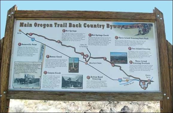
“Main Oregon
Trail Back Country Byway”
The
Oregon Trail was one of the main overland migration routes on the North
American continent, leading from locations on the Missouri
River to the Oregon Country.
Between 1841
and 1869 the Oregon Trail was used by settlers, ranchers, farmers, miners, and
business men migrating to the Pacific Northwest.
The eastern half of the trail was also used by travelers on the California
Trail, Bozeman Trail, and Mormon Trail which used much of the same trail before
turning off to their separate destinations. Once the first transcontinental
railroad by the Union Pacific and the Central Pacific was completed in 1869,
the use of this trail by long distance travelers rapidly diminished as the
railroad traffic replaced most need for it. By 1883 the Northern Pacific
Railroad had reached Portland,
Oregon, and most of the reason
for the trail disappeared. Roads were built over or near most of the trail as
local travelers traveled to cities originally established along the Oregon Trail.
The Idaho
Chapter of the Oregon-California Trails Association (IOCTA) has submitted an
application for designation of an Idaho State Back country Byway called the
“Main Oregon Trail Back Country Byway’. This Back Country Byway will follow the
main Oregon Trail from three Island Crossing of the Snake River near Glenns
Ferry to Bonneville Point southeast of Boise.
The route provides access to the ruts and swales of the Oregon Trail as it
stretches northwest across the desert and farmland of Elmore and Ada
Counties.
The
proposed backcountry byway will have a variety of educational and interpretive
signage to identify historical sites and public access points to the Oregon Trail.
The start of the Main Oregon Trail Back
Country Byway takes you over the Snake River, named for the people who once lived in
the high desert surrounding it. The story is that they marked sticks with the
image of a snake and posted them to mark their territory. When they greeted
people, they made a motion with their hand imitating the gliding motion of a
snake.
Today, an affectionate name for the Snake River, the longest river in Idaho at 1,056 miles, is
the “Mighty Snake.”
The byway
route starts at Exit 121 of Interstate 84 and takes Frontage Road to the left
and over the Snake River to Pasadena Valley Road. The trail then
takes a right onto Rosevear Road and on up over
the top of the hill onto Slick
Ranch Road to the Three Island Crossing Overlook.
"Roosevear
Gulch—the wagon train came down through the gulch, then up toward a peak, and
then drops toward the three islands. There were two trails: one crossed at the
islands to the north side of the river and the other followed the river along
the rim on the south side to a point and on around. If they crossed here, they
went up a draw toward Teapot Dome. Some did
try to float from Glenns Ferry to Boise!
If you chose to cross, then you crossed the Snake River
twice; if you crossed the landscape to bypass the water crossing risk, the
route was dusty and long, and offered little grass." (These markers are
located on the hill overlooking the crossing.)
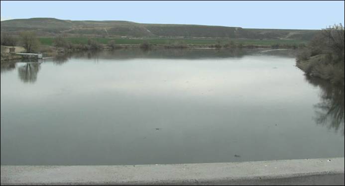
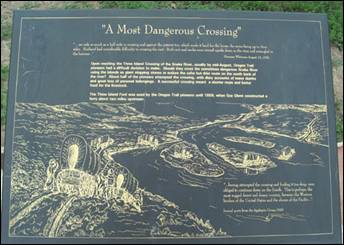
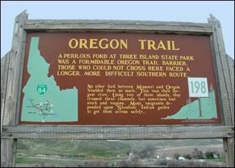
Approaching Three
Island Crossing
(of the Snake River) meant the emigrants had a
difficult choice. Oregon Trail emigrants
knew this spot well. It was one of the most dangerous river crossings on the
historic trail.
They could make a dangerous river crossing here for a
direct route to Ft.
Boise or stay on the
south side of the Snake and follow the river around the bend. About half made
the decision to cross using the three islands in the Snake as stepping stones.
It would not be easy.
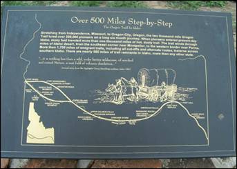
The trail played a significant role in the exploration and settlement of
western America.
The original course of the Oregon Trail was from Independence,
Missouri to Oregon
City in Oregon’s
Willamette Valley. Oregon
Trail emigrants traveled the trail from the late 1830s throughout
the 1860s. From the early 1800s, explorers and fur trappers had traveled this
Native American hunting and trading corridor.
The Oregon Trail entered Idaho
in the southeast corner of the state. At Fort Hall, it joined the Snake River. Many followed the south bank until this
crossing was reached near Glenns Ferry. The route left Idaho
near the site of old Fort Boise, near Parma,
after winding through 500 miles of the state.
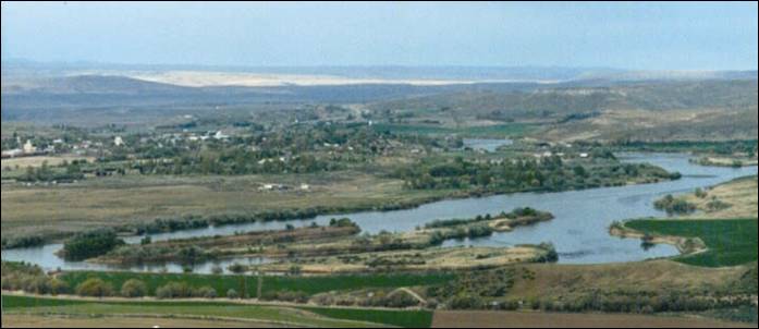
This photo was taken on the hillside off of Sailor Creek Road. Three Island State
Park is located center-right in the photo. Modern
travelers will find a stay at Three
Island State
Park much more hospitable than did the pioneers.
The park offers a full-service campground, cabins, picnic areas, historical
interpretive programs and a fascinating interpretive center.
The Main Oregon Trail Back Country Byway,
continues on Slick Ranch Road
above the Three Island Crossing and down to Slick Bridge
and then onto Highway 30. From there you will head east to the City of Glenns Ferry.
Glenns Ferry is truly a unique place,
besides the step back into what feels like the old West with the architecture
left from a time long ago, it’s one of the friendliest most welcoming places
still around. Located halfway between Boise and Twin Falls just off I-84
you should stop into this little gem and experience some of the unique shops
and places to visit, promising of a time well spent. There you can find the Three Island
State Park which is one
of the most serene and well-maintained parks in the state. The Oregon Trail
History and Education
Center is a special treat
located inside the state park which both commemorate the history there.
Construction of The Oregon Trail History & Education Center was completed
in 2000. Both park and center have a gorgeous view of the Snake
River which is also good for fishing.
The Oregon Trail History and Education Center will open Thursday, March 31,
2011. Hours of operation are Thursday
thru Sunday, 9:00am to 4:00pm.
Admission to The Oregon Trail History &
Education Center is free; however a $5 Day Use Vehicle Entry Fee is assessed
per vehicle, per day at the park entrance for non campers.
Idaho State Park Annual Passports offer
tremendous savings for day visits for individuals or families planning to
frequent their Idaho State Parks by providing unlimited vehicle access for the
calendar year. The $40 sticker can be
purchased at any Idaho State Park, Regional
Service Center
(Boise, Idaho
Falls and Coeur d'Alene)
or by calling (208) 334-4199. A second pass can be purchased for just $15.
Also in town, a great old theatre,
registered on the national historic register, hosts weekend melodramas and
dinner barbecues all summer long. So if you are lucky enough to be in town to
catch a show it will be an experience to remember. For kids there is an
immaculate community swimming pool, which is located in the local city park.
Also a very nice boat dock area invites fishermen, water-skiers, and jet skies
to take advantage of the cool water in the summer heat. And, if you are so
inclined, an interesting old museum is situated in the middle of town and
provides interesting historical facts concerning the area.
Glenns Ferry and their 100 years
Long before there was anyone at a place called Glenns Ferry
there were Native Americans using what was to become the Oregon
Trail. The trail of Chief Buffalo Horn, the Shoshone Indians, the
Bannocks and other Native American tribes was the link between the Indian
cultures of the Plains and the Midwest who
hunted buffalo, and the ways of the Northwest tribes whose dietary staple was
salmon and other fish. At the Three
Islands, these cultures
met.
The three island crossing of the Snake River by pioneers was more than just a test of
will, stamina, and brute strength. The crossing was a transformation from one
culture to another, from one country to another. The crossing was the place
where you either committed to the new West or you went back. Those who crossed
had clearly committed to their right of Manifest Destiny.
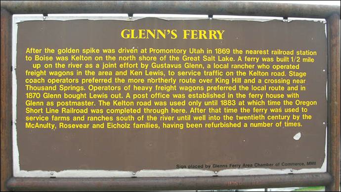
In the spring of 1883, the locality was
invaded by a force of tracklayers. It was at this time, when the construction
crews laid the tracks of the Oregon Short Line
Railroad, that the actual town of Glenns
Ferry came into existence. The establishment of a post
office, and O.S. Glenn having been appointed postmaster, the site required a
formal name. And what more suitable a name than “Glenns
Ferry” in recognition of the contributions made by the Glenn family. The
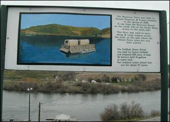
railroad led to the eventual discontinuances of the ferry boat service around
1889.
In 1886, W.M. Stockton platted the land that
Glenns Ferry stands on. He owned the town site for several years and watched
Glenns Ferry grow into a thriving and prosperous town.
But the town was not without setbacks. Fire
hit the town not only in 1893, but in 1897 and 1906.
The devastating fire in 1893 destroyed the
business portion of the town. The destruction included a drug store, post
office, store and warehouse, saloon, meeting hall, lodging house, meat market
and barber shop. Several residences were destroyed. But the buildings were soon
replaced and Glenns Ferry continued to survive.
But four years later (1987), another fire
destroyed more businesses. Included in that fire was a hotel,
restaurant, saloon, shoe shop and another restaurant that was vacant.
By the time Glenns Ferry was incorporated in
1909, the latest fire had destroyed more buildings. But each time rebuilding
was done. A year before it was incorporated, the town had the following
businesses: a large general Merchandise store, Mercantile Co. that supplied
staple goods to sheep camps every week, a bank, meat market, lumber company and
hardware store, an economy store, drug store, two-chair barber shop, livery
stable, lodging house, and a tailor shop. There was also a cigar store and a
saloon.
The proprietors of these businesses were the
Commercial Club. They were responsible for many good things done in and for the
community until the incorporation of Glenns Ferry in 1909.
The Oregon
Trail takes you on through Glenns Ferry to the Three Island
State Park and back out
to Bannock Avenue
to the Old Oregon Trail Road
near Exit 120 of Interstate 84. The Trail travels northwest as it follows the Oregon Trail via Old Oregon trail Road, Ryegrass Road, Ross Road, Wilson
Road, and Teapot Road
to Highway 20.
Along the Trail you will see excellent
undisturbed ruts of the main Oregon Trail.

The opportunity to view and hike on the Oregon
Trail in an environment very similar to that of the emigrants is
an important benefit of this proposed byway. There are a number of access
locations along the byway where the traveler may experience this opportunity.
These photos above are perfect examples of the ruts of the main Oregon Trail; notice the marker in the above left
picture, they are well displayed and easy to locate.
Above right is one of the most famous of Oregon Trail sites in Idaho,
the remains of the natural hot springs can be seen. This was the old bath house
just off Teapot Road.
To the right more of the well preserved ruts of the main Oregon
Trail.
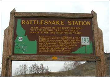
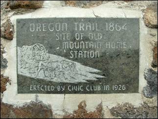
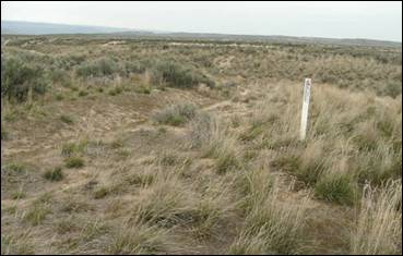
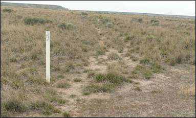
Mountain Home originated as a stage stop (Rattlesnake Station, founded
in 1864) for the famous Overland Stages eight
miles from its present location. When the railroad (Oregon Short Line) came through in 1883 it
brought with it a new mail delivery service. The postmaster and stage agent, Jule Hage, packed up the post
office and moved it down the hill to the railroad. Along with him came the name
and settlement of Mountain Home.
Mountain Home was
incorporated as a village in 1896. The initial village board consisted
of A.B. Clark, R.F. Whitney, W.J. Turner and G.F. Mahoney.
Mountain Home became a shipping and
distribution center for the livestock, mining and logging business.
Mountain Home Air Force Base, located 10
miles from Mountain Home, was established during the early stages of World War
II. The Air Base would become one of the major life lines for Mountain Home.
When irrigation systems were built, with the
help of high-lift pumping and the construction of irrigation dams, the
agricultural industry became stronger and much of the desert land was opened to
farming. Thousands of acres of land could now produce grain, hay, sugar beets,
potatoes, and beans.
Livestock production and, more recently, the
dairy industry have also made a considerable contribution to the local economy.
Mountain Home has a current population of
approximately 14,600 and is a community of diverse cultures. It sets at an
elevation of 3,143 feet. The hottest month is July and the coldest is January.
Average annual precipitation is 10.7 inches.
Mountain Home is especially proud of its
parks, visitor’s center, golf course, and museum.
Being centrally located in Elmore County,
Mountain Home is referred to as “The Hub of Elmore County”.
From Rattlesnake Station the Main Oregon
Trail Back Country Byway will travel south on Highway 20 and then right on
Reservoir Road, west on 27th N., north on 18th E., west
on 39th N., and then north on Canyon Creek Road. Near the foothills
you will come to an intersection of Canyon
Creek Road, Syrup Creek Road, and Immigrant Road. If you travel up Immigrant Road a
ways you will come upon the Kelton Road and Main Oregon
Trail crossing. This portion of the trail was noted for its rockiness. The
desert is littered with lava rocks over which the wagons bounced for many
miles.
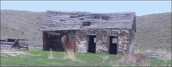
If you take a left at the intersection, you
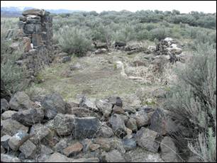
will come upon the old Canyon Creek Stage Station. The remains of the stage
station are still standing.
Canyon Creek Station was a popular camping
location and later became a stage station on the Overland Road. Canyon Creek Station was
homesteaded in the 1860’s and a stage station was built. The remains of the
stage station are still standing.
The station consisted of two buildings, one
was the cooking building, and the other was the sleeping building. The mortar
used deer hair to hold the rocks together. The area is private property.
The Main Oregon Trail Back Country Byway
continues on Mayfield Road
to Ditto Creek overlook. An old Indian trail ran up Ditto Creek towards the
Camas Prairie. Emigrant travelers found scarce grass along the creek.
Next along the trail is Browns Creek. The remains
of emigrant names written on the surrounding boulders with axle grease can
still be seen in the area.
On up the trail a ways you will come upon
Mayfield Station, a rock stage station visible in the field to the north of the
road. It was built in 1878.
The Indians conducted horse races in the
valley. The area was homesteaded and the small community of Mayfield developed.
The old dance hall (community center), school house, and teacher’s house still
remain.
Mayfield Stage Station was built in 1878. This photo was taken on April
11, 2010. A cemetery sits on the ridge above the area.
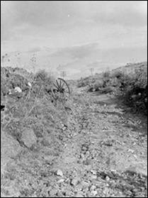
On down the trail you will come to Blacks
Creek crossing. The Oregon Trail crosses the
byway route and climbs the ridge to Bonneville Point. Excellent ruts remain in
the area for hiking.
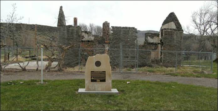
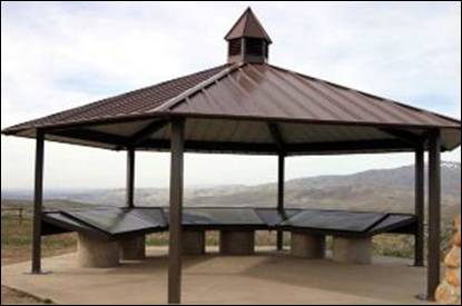
Last place, but not the least point of
interest, is Bonneville Point. Interpretive signs and monuments are located on
the ridge overlooking the Boise
valley. The trees along the Boise
River in the valley below
were the first trees the emigrants had seen in several weeks.
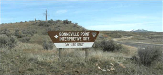
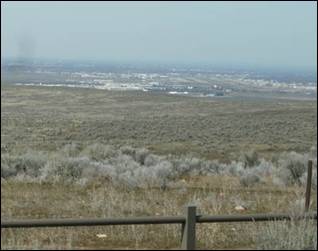
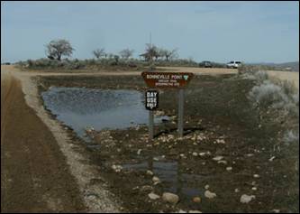
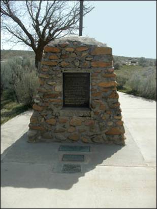
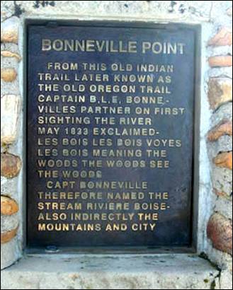
Bonneville Point
Bonneville Point is one of the places
closest to Boise where you can see the Oregon
Trail ruts and view the entire Boise
Valley area. This is the
spot where Captain Benjamin Bonneville and his expedition party overlooked the
valley he named Les Bois, site of the city that today bears the same name —
Boise. This scenic vista sweeps the entire Treasure Valley.
It features outstanding panoramic views of the Boise Valley
and the Snake River Plain. Bonneville
Point is also an access point for the Oregon Trail
and a place to hike, picnic, and view wildlife.
Bonneville
Point is ten miles east of Boise
and 26 miles west of Mountain Home,
Idaho. Take the Blacks Creek exit (#64) off Interstate
84. Travel north on Blacks Creek
Road four miles, then follow signs to Bonneville
Point.
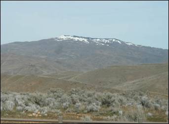
Les Bois
Valley or as we now call it Boise. Just over
the rolling hills is the Boise
River.
As you can see by the standing water, the snow in this
area had melted not too long ago!
Bonneville Point
Interpretative Kiosk Oregon Trail (photo ISSH)
Photos
(unless otherwise noted) are by Ed Walter. Information compiled from Wikipedia,
Idaho State Historical Society and the Idaho Chapter of the Oregon-California
Trails Association.
The byway is now prominently displayed on
the IOCTA website.
Captain Benjamin Bonneville
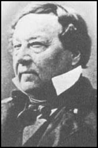
Benjamin Louis Eulalie de
Bonneville (April 14, 1796 – June 12, 1878) was a French-born officer in the
United States Army, fur trapper, and explorer in the American West. He is noted
for his expeditions to the Oregon Country and the Great Basin, and in particular
for blazing portions of the Oregon Trail.
During his lifetime, Bonneville
was made famous by an account of his explorations in the west written by
Washington Irving.
The expedition that would become
the most famous accomplishment of his life began in May 1832, when he left Missouri with 110 men,
including Nathaniel Jarvis Wyeth. The voyage was financed by John Jacob Astor,
a rival of the Hudson's
Bay Company. The expedition proceeded up to the Platte
River and across present-day Wyoming. They reached
the Green River in August and built a winter fort, which they named Fort Bonneville.
In the spring of 1833 he
explored along the Snake River in present-day Idaho. He also sent a party of men under
Joseph Walker to explore the Great Salt Lake and to find an overland route to California. Walker
discovered a route along the Humboldt River across present-day Nevada, as well
as Walker Pass across the Sierra Nevada, a path that later became known as the
California Trail, the primary route for the immigrants to the gold fields
during the California Gold Rush. Much speculation has surrounded Bonneville's
motivations for sending Walker to California. In
particular some historians have speculated that Bonneville was attempting to
lay the groundwork for an eventual invasion of California,
then part of Mexico,
by the United States Army.
John McLoughlin,
the director of the Columbia operations of the Hudson's Bay Company at Fort
Vancouver on the Columbia
River, heard of Bonneville's mission and forbade his traders from
doing business with Bonneville and his men. Bonneville reported that many of
the Native Americans he encountered in the Snake River were also reluctant to
displease the Hudson's
Bay Company by trading with the Americans.
In the summer of 1833 Bonneville
ventured into the Wind River Range in present-day Wyoming to trade with the
Shoshone. By this time he realized that he would not be able to fulfill his
obligation to return east by October. He wrote a lengthy letter to Macomb summarizing some of his findings and requesting
more time, specifically in order to survey the Columbia and parts of the Southwest before
his return.
After spending the early winter
at Fort Bonneville,
he set out westward in January 1834 with the goal of reaching the Willamette Valley. He and his men traveled up the
Snake River, through Hells Canyon, and into the Wallowa Mountains, where they
found a hospitable welcome by the Nez Perces along
the Imnaha
River.
On March 4, 1834, they reached
Fort Nez Perces, the outpost of the Hudson's
Bay Company at the confluence of the Walla Walla River
with the Columbia.
Pierre C. Pambrun, the HBC commander of the fort
welcomed him but refused to do business with him. Empty handed, Bonneville and
men retraced their course back to southeast Idaho
and made camp on the Portneuf River.
In July he made a second trip
west, determined to trade with the Hudson's
Bay Company. He followed an easier route across the Blue Mountains, where he
met Nathaniel Wyeth once again and camped along the Grande Ronde
River. By this time he
and his men had become desperate for food and supplies. At Fort Nez Perces, they found the same rejection from Pabrun. Instead of returning immediately east he and men
journeyed down the Columbia towards Fort Vancouver.
Along the river, he attempted to trade with Sahaptins
but without success. He came to realize that he would probably receive the same
rejection from McLoughlin at Fort Vancouver
and decided to turn back east.
He spent the winter of 1834-1835
with the Shoshone along the upper Bear River and in April 1835 began the voyage
back to Missouri.
He reached Independence by August and discovered
that although his letter requesting an extension had arrived, it had not been
delivered to Macomb.
In the meantime, his commission had been revoked.
After leaving Bonneville
Point, we decided to head on into Boise
and take another aerial view from a little higher up. Now if you have never
been up on Table Rock, you have been missing out on one fantastic view of Boise.