~Twin Falls County~
__________________________________________________________________________________
Twin Falls County was established on
February 21, 1907 with its county seat at Twin Falls. It was named for the
nearby waterfalls on the Snake River. The Snake River is the county’s northern boundary. As of the
2010 Census, the county had a population of 77,230.
Prior to the 1860s, the Twin Falls County
area was an unorganized part of Shoshone lands, then as part of the Oregon
Country. The area was first organized as part of the original Owyhee County
in 1864 as part of Idaho
Territory. In 1879 it was
partitioned away from Owyhee County to form part of Cassia County.
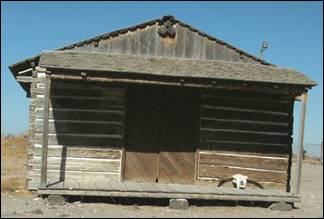
The first permanent settlement in the area
was a stage stop established in 1864 at Rock Creek for the Ben Holladay Stage
Line. In 1865 James Bascom built the Rock Creek
Store. In 1876 Herman Stricker purchased the store
and remained the proprietor until it closed in 1897.
In its day, Rock Creek saw westward migration, freight and passenger
traffic, robberies, gun fights, range wars, mining booms and busts, water
disputes, births, deaths, and marriages-organ music and flowers. Its doors
welcomed Oregon Trail travelers, cowboys,
farmers, miners, Indians, Chinese, Irish, British, Russians, Danes, Swedes,
Germans and more. Some were well known including Ezra Meeker, cattle barons
Jasper and A.J. Harrell and John Sparks, Diamond Jack, Buffalo Horn; many were less known.
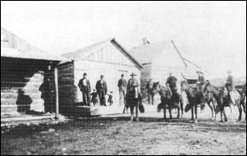
Rock Creek Station was the first trading post on the Oregon
Trail west of Fort Hall. It served as a
saloon, dance hall, post office, polling place, and supply post for emigrants
traveling west. At one time, the Rock Creek Station was the largest stage
station between Fort Hall and Fort
Boise. Today, travelers
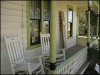
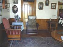
can visit the log store, two stone cellars, a cemetery and the 1901 Stricker home.
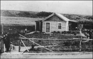
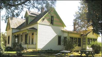
The Stricker
family lived in a six-room log cabin (left) until it burned down. Only Lucy’s
walnut bedroom set, her beloved organ, and pictures were saved. The family
built a new home the same year. The walls are constructed of hand-hewn upright
logs, hauled from Albion. In 1916, the house
was extended, adding a formal dining room, kitchen, bath, service entrance, sun
porch, and storage area. The upper floor was a hotel for cowboys, travelers,
and later for construction workers on the Milner Dam and Twin Falls Canal
System. The photo to the right and those below are of the house as it looks
today. Photos by Ed Walter.

The Carey Act, a federal reclamation and land
claim law, was important to the development of agriculture in the Rock Creek
area. Federal public lands were donated to individual states, which then held
the land until a private reclamation proposal was developed for a given tract.
Individuals could then “prove up” and claim up to 160 acres of land. The men pictured
below were instrumental in funding and promoting irrigation projects in the
region.
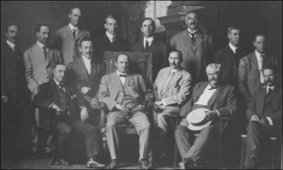
Seated (l-r): J.H. Purdy, A.C. Milner,
F.R. Gooding, George Baird, Frank L. Buhl, I.B.
Perrine. Standing (l-r): D.C. McWaters, H.L.
Hollister, M.J. Sweeley, Fentris
Hill, S.H. Hays, Fred Voigt, C.A.
Tush, R.W. Faris. Photo and info from Idaho State
Historical Society.
Even after Idaho
became a state in 1890, there were only a handful of successful agricultural
operations in the Snake River
Canyon, but the lack of
infrastructure and the canyon’s geography made irrigating the dry surrounding
area improbable at best.
To address this issue, in 1900 I. B.
Perrine founded the Twin Falls Land and Water Company largely to build an
irrigation canal system for the area. After an August 1900 survey of 244,025
acres in the area, in October 1900 the company was granted the necessary water
rights to begin construction of the irrigation system. Several lots in the
surveyed area were set aside specifically for future townsites.
These lots eventually became the settlements of Twin Falls, Kimberly, Buhl, Filer, Hansen and
Murtaugh. In 1902 the project nearly failed as most
of the original investors pulled out, with only Salt Lake
businessman Stanley Milner maintaining a stake in the company.
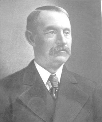
Ira Burton Perrine (May 7, 1861 - October 2, 1943) was an Idaho farmer, rancher
and businessman. Perrine is generally credited as the founder of Twin Falls and other towns in the Magic Valley
region.
Perrine was born in Delaware, Indiana, a son of George and Sarah
Burton Perrine, and a descendant of Daniel Perrin, “The Huguenot”. He
moved to Idaho Territory
in 1884 and established a farm and ranch operation in the Snake River Canyon
near present-day Jerome. Perrine was a successful farmer and rancher who among
other things received a gold medal for his fruit display at the 1904 Louisiana
Purchase Exposition in St. Louis.
The ranch remained in the Perrine family until 1964, when it was sold and
became part of Blue
Lakes Country Club.
Although Perrine’s operation in the
canyon received plenty of water, the surrounding area could not be easily
irrigated and was therefore largely unproductive. Beginning in 1893 Perrine
worked to convince private financiers to build a dam on the Snake
River along with a corresponding canal system to irrigate the
area. This work culminated in the 1900 founding of the Twin Falls Land and
Water Company and the subsequent completion of Milner Dam in 1905.
After Twin Falls was founded in 1904,
Perrine served as a bank president and owned a hotel in the new city.
Perrine is buried near his former ranch in Jerome County.
Perrine Bridge
and I. B. Perrine Elementary School in Twin
Falls are named after him.
By 1903 Perrine, who had been a successful
farmer and rancher in the Snake River Canyon, had obtained private financing
from Milner and others under the provisions of the Carey Act of 1894 to build a
dam on the Snake River near Caldron Linn. Completed in 1905, Milner Dam and its
accompanying canals made commercial irrigation outside the Snake River Canyon
practical for the first time. As a result Perrine is generally credited as the
founder of Twin Falls.
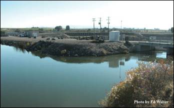
“On March 1, 1905, Frank Buhl gave a
ceremonial pull on the wheel on a winch and the gates of Milner Dam were
closed, and the gates to a thousand miles of canal and laterals were opened,
and the Snake River was diverted, and that night Shoshone Falls went dry as the
water rushed across the desert far above, and Perrine’s vision was realized,
and 262,000 acres of desert were shortly transformed.” Photo (right) and
information is from Milner Dam Interpretative Kiosk. Photo on the left was
taken October 7, 2012.
Most of the county’s other towns were
established during this period as well. In response to local government needs
for these new communities, which were as much as 80 miles away from Cassia County’s
seat at Albion, Twin Falls
County was created by the
Idaho Legislature on February 21, 1907.
Twin Falls city
was founded in 1904 as a planned community, designed by celebrated
Franco-American architect Emmanuel Louis Masqueray,
with proceeds from sales of town site lots going toward construction of
irrigation canals. Twin Falls
was incorporated as a village on 12 April 1905. The city is named for a nearby
waterfall on the Snake River of the same name.
In 1907 Twin Falls became the seat of the
newly-formed Twin Falls
County.
The original town site follows a unique
design. It is laid out on northeast-to-southwest and northwest-to-southeast
roads. The northwest-to-southeast roads were numbered and called avenues, while
the northeast-to-southwest roads were numbered and called streets. Only two
central streets, the northwest-to-southeast
Main Avenue and the northeast-to-southwest Shoshone Street,
were named. It is purported that the reason this was done was to allow sun to
come into every room in the home at some point during the day. This system
created situations where one side of a street may have an entirely different
address than the other, and where the corner of “3rd and 3rd,” for example, was
in more than one location. In 2003 the numbered northeast-to-southwest streets
were renamed to alleviate decades of confusion. Later city roads, such as Blue
Lakes Boulevard, Addison Avenue
and Washington Street,
are laid out in standard north-south and east-west orientations.
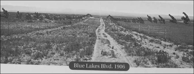
Hard to believe this is what Blue Lakes Boulevard
looked like in 1906.
Photo from Shoshone Falls Interpretative Kiosk.
After Milner Dam was constructed
agricultural production in south-central Idaho
increased substantially. In 1909 the privately-owned Twin Falls Land
and Water Company was reorganized as the shareholder-owned Twin Falls Canal
Company. Twin Falls
became a major regional economic center serving the agriculture industry, a
role which it has sustained to the present day. The city became a processing
center for several agricultural commodities, notably beans and sugar beets. In
later years other food processing operations augmented the local economy. By
1960 Twin Falls had become one of Idaho’s largest cities
even though its origins were still within living memory for many.
Twin Falls
became the center of national attention in September 1974 thanks to an attempt
by Evel Knievel to jump the
Snake River Canyon in a specially-modified rocket
cycle. Watched by millions on television, the attempt ultimately failed due to
high winds and a premature deployment of Knievel’s
parachute. The foundation of the launch ramp, which lies on private land, can
still be seen.
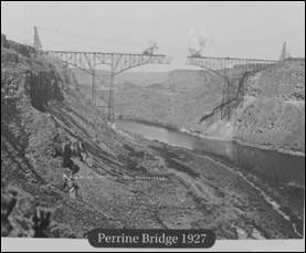
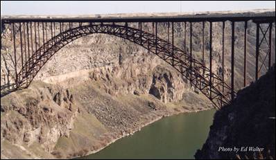
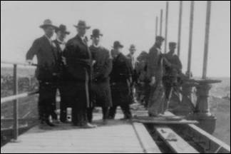
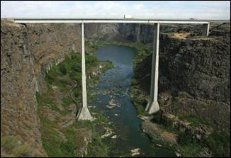
The Perrine Bridge, completed in 1927, crosses the Snake River Canyon
north of Twin Falls.
At the time of its construction it was the highest cantilever bridge in the
world. It was replaced in 1976 with the current span, which is 1,500 foot long
and 486 feet above the Snake River. It is
still the highest bridge in Idaho.
The privately financed $650,000 structure was originally a toll bridge,
but the tolls were eliminated in 1940 after the bridge was purchased by the
state of Idaho.
By the early 1970s, the original bridge was outdated and unable to
handle heavy loads and required replacement. Construction on the current bridge
was completed in July, 1976 at a cost of $9,700,000. The original bridge was
demolished.
The bridge is named for I. B. Perrine, who spearheaded the early 20th
Century irrigation projects in Idaho’s Magic Valley
region and is largely credited as the main founder of Twin Falls. Photo on the left is from Shoshone Falls Interpretative Kiosk.
Buhl was founded on April 17, 1906. It was named for
Frank H. Buhl of Sharon, Pennsylvania,
a major investor in a Carey Act project known as the Twin Falls South Side project,
which introduced large-scale irrigation to the Magic Valley
in the early 20th Century. The history of Buhl began with the vision of men who
could see the potential hidden beneath the sagebrush-covered area. The U.S.
government was interested in developing the west for settlement and provided
financial assistance for early settlers under the Carey act and the Bureau of
Reclamation Act in the early 1900’s. Eager financiers from the east arrived in
the area in the early 1900’s to look at the possibilities. These men had been
interested in a proposed irrigation project for the land in Southern
Idaho called the Twin Falls South Side project.
Frank Buhl came west from Sharon,
Pennsylvania, to Salt Lake City, Utah
in 1901 to examine a mining property that interested him. Discovering that it
had already been sold, he decided to investigate a proposed irrigation
development in southern Idaho
(Twin Falls South side project). Mr. I.B. Perrine met Bulh
at the train depot in Shoshone and introduced him to Peter Kimberly. Buhl and
Kimberly formed the corporation that accomplished the project.
The townsite of
Buhl was platted in 1905, and the Twin Falls Investment Company sold lots at
Broadway and Main Street
for $1,750 each, in April, 1906. Much to the dismay of some early residents,
the town was laid out in the same diagonal design as the city of Twin Falls. Normally a
town is laid out in a north-south, east-west direction for ease of finding
places, but the Buhl town site was arranged to get the most benefit from the
sun.
It was decided by members of the Twin Falls Land and Water Company that the town
should be named after Frank H. Buhl because of his decision to donate land for
the initial town site. Mr. Buhl continued to be a major support for the fledgling
town throughout his life. He contributed $25,000 towards the building of the F.H. Buhl
High School (now the
middle school building) and the land for Faris Field
(a game field used for baseball and soccer).
Over 40 historical buildings encompass the
downtown section of Buhl. The tree-lined streets are in the process of being
upgraded with new sewer and electrical lines, new sidewalks and new urban
furniture (street lamps, trash receptacles and benches).
Lush grasses and fertile ground encompass the
land around the rural town of Buhl.
Along with a moderate climate, this land is ideal for raising animals and
crops. Annual rainfall is about 10 inches. At an elevation of 3,660 feet, there
are over 300 days of sunny skies.
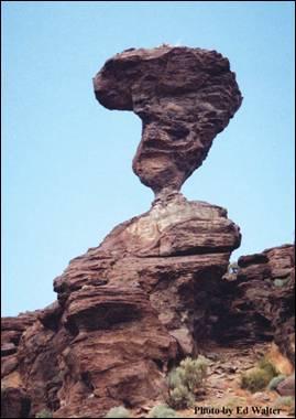
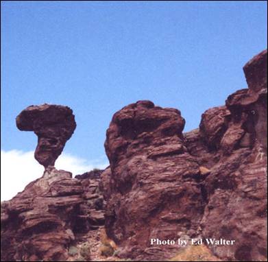
Balanced Rock - South of Buhl, 16 miles off Highway 30 in the Salmon Falls
Creek Canyon,
is the world-famous Balanced Rock. Over 48 feet tall, the rock balances on a
pedestal 3 feet by 17 inches and weighs 40 tons.
Sinking Canyon - Located six miles up the course of Salmon Falls Creek,
is an interesting natural phenomenon called Sinking Canyon.
The creation of the “canyon” created quite a stir in August of 1937. An article
in the August 12, 1937 issue of the Buhl Herald read, “West End people have
been witnessing an unusual geological phenomenon this week as a large area of
farmland has dropped on an average of 150 feet to form a new canyon joining
Salmon Canyon about five miles west of Buhl.”
The 12 acre block of land slid over a three week period.
Castleford
- Castleford was named for an early crossing of Salmon Falls Creek. The ford
was so named because of the odd-shaped obelisks of rhyolite
near the stream. The ford, used by pioneers in 1849, was also used by the Kelton-Dalles stage route.

Filer
was named after Walter G. Filer, who served as general manager of the Twin
Falls Water and Land Company. The city was established in 1906 as the terminus
of the Oregon Short Line branch of Twin
Falls. Walter Filer was a mining engineer and surveyor
from Sharon, Pennsylvania,
who supervised the construction of the Milner diversion dam on the Snake River. Since 1916, the City of Filer
has been the home of the Twin Falls County Fair & Magic Valley
Stampede.
Kimberly was founded in 1905. It is named after Peter L.
Kimberly, a major investor in the construction of Milner Dam which made
commercial irrigation practical in the area.
Murtaugh is a small community originally known as Drytown. The town was later named for Mark Murtaugh, the assistant superintendent of the Twin Falls
Canal Co., who was head of construction on the South Side Irrigation Project.
Other towns in Twin Falls County
include Hansen Hollister,
and Rogerson.
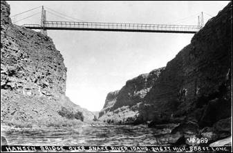
Hansen Bridge - Until 1919, when a high
suspension bridge was completed here, this 16-mile long Snake
River gorge could be crossed only in a rowboat.
With 14 cables, each more than 900 feet long, a $100,000 suspension
bridge was wide enough to accommodate two lanes of farm wagons or early cars
that had begun to gain popularity then. From its deck nearly 400 feet above the
Snake River, travelers had a spectacular view
that still can be seen from the replacement, built in 1966.
Old Photo - The original Hansen Bridge,
built in 1919 as a Suspension Bridge. Located on State Highway 50, 345 Ft. High, 688 Ft.
Long. Photos from Wikipedia
Excavations at Wilson
Butte Cave
near Twin Falls in 1959 revealed evidence of
human activity, including arrowheads that rank among the oldest dated artifacts
in North America. Later Native American tribes
predominant in the area included the Northern Shoshone and Bannock.
The first people of European ancestry to
visit the Twin Falls area are believed to be
members of a group led by Wilson Price Hunt, which attempted to blaze an
all-water trail westward from St. Louis, Missouri, to Astoria,
Oregon, in 1811 and 1812. Hunt’s
expedition met with disaster when much of his expedition was destroyed and one
man was killed in rapids on the Snake River
known as Caldron Linn near present-day Murtaugh. Hunt
and the surviving members of his expedition completed the journey to Astoria by land.
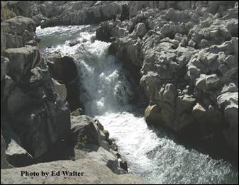
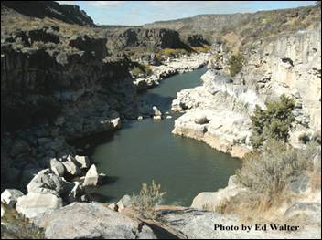
Wilson Price Hunt’s expedition met with
disaster and one man was killed at this 40 foot wide passage on the Snake River
near the Oregon Trail in 1811. During the spring
and early summer the force of the force of the waters is a sight to see. These
photos above were taken in early October when the waters were calm. A close
look at the rocks and you can see the perfectly round holes that had been
drilled into them by the swift churning waters.
In 1812 and 1813, Robert Stuart
successfully led an overland expedition eastward from Astoria
to St. Louis which passed through the Twin Falls area. Stuart’s
route formed the basis of what became the Oregon Trail.
Some 150 years later, Robert Stuart Middle School
in Twin Falls
was named in his honor.
Source: Twin Falls County, Buhl Chamber of
Commerce, Friends of Stricker, Inc., Elmore County
Press, Wikipedia, and web links.
Twin Falls County