~ Camas County~
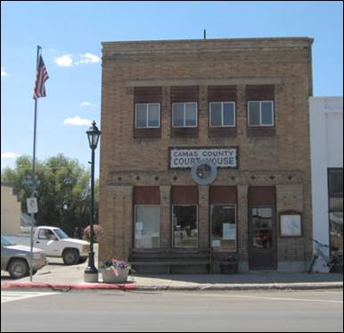
Camas County Courthouse
Camas County
was created by the Idaho Legislature on February 6, 1917, by a partition of Blaine County.
It is named for the camas root, or Camassia, a
lily-like plant with an edible bulb found in the region, which was used as a
food source by Native Americans and settlers. Camas County
covers 1,075 square miles or 688,000 acres.
When the cavalry was stationed at Fort Boise
the southern portion of the Camas Prairie was an important feeding ground for
their horses. In 1869, a treaty ratified by the US Senate provided a portion of
the "Kansas Prairie" instead of the "Camas Prairie" to be
retained by the Bannock Indians. The error may have made by the person who
transcribed the treaty. Since there was no "Kansas Prairie" in Idaho, the treaty rights
of the Bannocks were ignored. When they found a few settlers were allowing
their hogs to feed on the Bannocks' traditional food source, the camas root,
they objected (without results), which was a major cause of the Bannock War of
1878. Development of the region was slowed by the heavy snows of winter and the
Bannock War, but farmers and rancher soon found good water, timber, grass, and
an abundance of fish in the streams. Soldier was the first town established on
Camas Prairie located about four miles northeast of Fairfield. When the railroad was built across
the county it bypassed Soldier and when Camas was organized as a county Fairfield
became the seat and most of the population moved there. The Lava mining
district lies a few miles southwest of Fairfield,
which attracted miners in the 1880s, but the main attraction of Camas County
has always been its agricultural lands.
Camas
County is bordered by Blaine County
on the north and east, Lincoln and Gooding Counties
on the south, and Elmore
County on the west. Most
of the population lives in the Camas Prairie, a high plain at an elevation of
5,100 feet situated between the Soldier
Mountains, at the southern end of the Sawtooth
Range, and the Bennett
hills which separate the Camas Prairie from the Snake River Plain to the south.
The
prairie is 28 miles long and 3 to 11 miles wide and slopes from west to east
and from north to south. Land ownership in the county is: 65% Federal Lands
managed by The Bureau of Land Management (BLM) and the Forest Service, 30%
privately owned, and 5% State lands.
Indians were the first human beings on the
Camas Prairie. However, American explorers and trappers were in the area as
early as 1811 when the Wilson Price Hunt Party sent members of their party
through southern Idaho to the Oregon coast.
The
French trappers, under the leadership of Donald McKenzie discovered Camas
Prairie on his way from Little Lost River in 1820.
In 1824 Alexander Ross Party, in the
employment of the Hudson’s Bay Company, came in by way of the Salmon River,
thence over the divide to Big Lost River and from Lost River they came by Trail
Creek to where Ketchum is now located. The party of John Work, also employed by
the Hudson’s
Bay Company, covered some of the same territory as the Ross Party, in the year
1832. Work came through the Smoky area but made no mention of Camas Prairie.
Camp
Wallace, located on
Soldier’s Creek, was established June 8, 1865 and abandoned September 20, 1865.
There is some evidence that the spot where
the encampment was located was named Soldier before the Army established
quarters there.
In 1854 after the Ward Massacre in Boise Valley,
some other emigrants were killed on Camas Prairie, and the next summer, Nathan
Olney camped on Camas Prairie with some soldiers on his way to Fort Hall.
Mr.
Frank Croner procured an affidavit from someone who
claimed to have gone through Camas Prairie, coming from Oregon with a contingent of soldiers on the
way east to some other encampment. He said they called it Soldier Creek and Soldier Mountain
before 1865 and prior to the establishment of Camp Wallace.
Apparently, “Soldier” was the name chosen when application was made for a post
office there and it must have been the choice of the citizens who applied for
the establishment of the post office.
There is a probability that settlers who came
there in the year 1880 and following were unaware that the military encampment
was known as Camp
Wallace. Why Captain Ephriam Palmer chose that name is unknown, perhaps it was
to honor the first governor of Idaho
territory, Mr. William Wallace.
Nathanial Wyeth, J.K. Townsend and others
finished building a trading post at Fort Hall in the summer of 1834. After its
completion they left the Malade River
Valley and went up on
“Kamas Prairie” and camped on a branch of the Malade.
They passed through Camas Prairie on their way west on August 17, 1834. In 1852
to 1855 this route was used by emigrant wagons headed for western Oregon, and in 1862,
Timothy Goodale led a large emigrant party that way.
September 1, 1864 military expedition of
about 30 cavalry men and about 30 infantrymen were sent out from Fort Boise
through Camas Prairie to Fort Hall to clear the area in all directions of
hostile Indians.
1880’s were documented as large cattle and
horse drives going through Camas Prairie from Oregon
to Omaha, Nebraska.
Hill
City at one time was the
largest sheep-shipping center in the world.
Between 1880 and 1885 mining had reached its
apex and other means of making a living were being sought.
A partnership or association of Rice &
Foster recruited people from all parts of the nation to come to Camas Prairie.
There were two distinct waves of immigration.
The first one began about 1880 and continued on into the nineties, slowing down
as it advanced. Most of the settlers who came during this period had no way of
knowing what kind of crops would grow in the short growing season or the other
problems they would encounter such as frost (because of the high altitude of
the area), the uncertainty of rain, and the invasion of grasshoppers and
crickets.
As to determine who was the first to settle
on Camas Prairie, is difficult. There are stories of a mysterious settlement on
Chimney Creek, from which the creek derives its name. A group of people
attempted to settle there many years ago, even before 1860. The meager evidence
gathered after five years of research gives an indication that it was one of
the early Mormon settlements.
If it was a Mormon settlement, the head
office has no record of such a settlement, it lost
contact with the Church in Salt
Lake. It had all the
earmarks of being a Mormon settlement. It was built in a string like fashion
and there were outdoor chimneys built along the creek from its source to almost
down to where it empties into the river.
Prior to the settlement of Camas County,
the Bannock Indians used the prairie as their summer camping area. Here they
gathered the Camas and Yampus roots and hunted wild
game.
When the cavalry was stationed at Fort Boise
the southern portion of the Camas Prairie was an important feeding ground for
their horses. In 1869, a treaty ratified by the US Senate provided a portion of
the "Kansas Prairie" instead of the "Camas Prairie" to be
retained by the Bannock Indians. The error may have made by the person who
transcribed the treaty. Since there was no "Kansas Prairie" in Idaho, the treaty rights
of the Bannocks were ignored. When they found a few settlers were allowing
their hogs to feed on the Bannocks' traditional food source, the camas root,
they objected (without results), which was a major cause of the Bannock War of
1878.
Following the Bannock War of 1878 (see
Bannock War below), the summer gathering of roots
tapered off dramatically, but still continued into the 1950’s.
Development of the region was slowed by the
heavy snows of winter and the Bannock War, but farmers and rancher soon found
good water, timber, grass, and an abundance of fish in the streams. Soldier was
the first town established on Camas Prairie located about four miles northeast
of Fairfield.
When the railroad was built across the county it bypassed Soldier and when
Camas was organized as a county
Fairfield became the seat
and most of the population moved there. The Lava mining district lies a few
miles southwest of Fairfield, which attracted
miners in the 1880s, but the main attraction of Camas County
has always been its agricultural lands.
In 1877, the
government opened the area for settlement and within two years the first land
filings were recorded in Boise.
Six years later, the first school was established. Eventually, a total of 17
small schools dotted the prairie serving the educational and social purposes of
the scattered communities. By 1948, most schools had consolidated with the Fairfield system. The last
rural school closed in 1953.
At one time, up to nine small towns thrived
in what is now Camas
County. The town of Soldier, located two miles north of Fairfield, was a bustling center of commerce,
culture and social activity. Soldier’s decline, however, began during the
formation of Fairfield
in 1911 occasioned by the arrival of the Oregon Short Line Railroad.
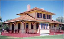
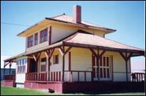
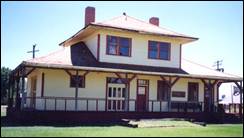
The railroad served the Camas Prairie
for a period of seventy years. A remnant of this bygone era and many of the
daily items from the pioneer days to the present still remain within the
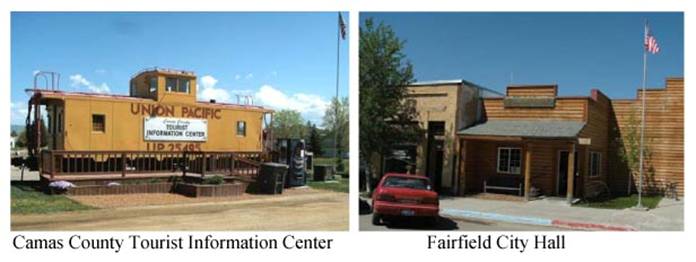
historic Railroad Depot/Museum building located in Fairfield.
Fairfield
Fairfield, located an hour from Sun
Valley, Idaho...is emerging as Idaho's best
"undiscovered" small ski town with its friendly, casual atmosphere and
year-round recreation:
Winter sun and fun includes excellent powder runs, snowboarding,
groomed skiing and cat skiing at Soldier Mountain Ski Resort and
adjacent unlimited back-country ski areas on National Forest Lands; hundreds of
miles of beginner to expert snowmobiling trails, Nordic-skate and cross-country
skiing. Area lodging is limited, so make reservations early!
Spring and Summer: With
a wide-open prairie and adjacent Forest Service access, the high mountain
desert dry air with long, sunny days and bright clear night skies provide
outdoor enthusiasts optimum recreational opportunities. Excellent
mountain biking, hiking, camping, fishing, horseback riding, bird and wildlife
watching, golf and photography. It's an undiscovered paradise for
recreation and RV travelers.
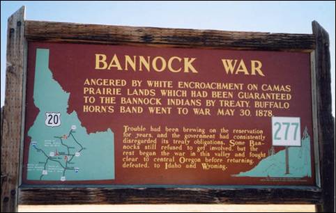
Bannock War
The Bannock War was a series of conflicts in 1878
between various Bannock, Northern Shoshone and Paiute tribes against the United States.
Camas (Camassia quamash) is a plant with a blue or purple flower which has
a nutritious bulb about the size and shape of a tulip bulb. For many of the
tribes in Idaho, Eastern Washington, Eastern
Oregon, and Western Montana, camas was a major
source of food. It was gathered in late spring or early fall. It was either
eaten raw or steamed in a pit for immediate consumption. To preserve the camas,
the bulbs were pounded in a mortar to make a kind of dough which was then
shaped into loaves, wrapped in grass, and steamed again. After cooking it for a
second time, the loaves were made into smaller cakes and dried in the sun.
Without adequate stock of camas, people would be ill prepared for the cold
winter months. In Idaho,
one of the most important camas areas was known as Great Camas Prairie.
The Bannock tribe was restricted to the Fort
Hall Reservation in Idaho
by the Fort Bridger Treaty Council of 1868. The tribe was experiencing a famine
as they competed with local settlers for game, and the rations provided by the
U.S government were too few to support the people on the reservation. In the
spring of 1871, the Bannocks and Shoshone traveled to nearby Great Camas
Prairie to harvest camas roots. They discovered that settlers had grazed their
hogs and livestock on the land, and many of the camas tubers had been eaten.
This increased the starvation pressure on the tribes and lead to increased
hostility.
General George Crook, a contemporary United States
military officer, commented that: "...it
was no surprise...that some of the Indian soon afterward broke out into
hostilities, and the great wonder is that so many remained on the reservation.
With the Bannocks and Shoshone, our Indian policy has resolved itself into a
question of war path or starvation, and being merely human, many of them will
always choose the former alternative when death shall at least be
glorious."
Source: Wikipedia, Camas
County, City of Fairfield,
Elmore County Press
Summer in El-Wyhee
Camas County
Camas
Chamber of Commerce
Geography
Located in southcentral
Idaho, Camas County
boasts 1071 square miles of geographic diversity. Let’s take a peek at just a
few of the highlights.
Spanning the center of the county from east
to west is the Camas Prairie – a high plateau valley with an average elevation
of 5000 feet. Approximately 125,000 acres of the prairie are devoted to crops
and pasture. Antelope, deer and other wildlife freely roam the prairie. And,
tucked against the Bennett
Hills on the west end of
the county is the Centennial Marsh – home to numerous bird species and a
popular attraction for birdwatchers. In mid- to late spring, the marsh and many
other parts of the prairie become a bluish purple sea of Camas Lilies.
The average annual precipitation on the
prairie is about 15.7 inches, most of which falls as snow. Again, diversity is
the theme with the southeastern parts of the county receiving only 11 to 12
inches of precipitation and the northwestern mountains receiving in excess of
25 inches. While the mean average temperature is 41* F., summertime highs
average a comfortable 70-75*. Temperature extremes have varied from a rare 101* in the
summer to an equally rare -60* in the winter. Residents enjoy bright sunshine
300 days of the year.
The ruggedly beautiful Sawtooth Mountains
reach for the sky in the northern half of the county. Four peaks tower above
10,000 feet with Baker
Peak, the tallest, at
10,174 feet. The Sawtooth
Mountains and their
foothills offer abundant recreation opportunities. Popular spring through
autumn activities include camping, backpacking, fishing, hunting and
sightseeing. Winter, too, presents plenty of opportunity for those who enjoy
downhill skiing, cross-country skiing and snowmobiling.
The Bennett Hills
to the south of the prairie are also popular for outdoor recreationists. Twin Lakes
(Mormon) Reservoir and Magic Reservoir are well-equipped to support large
number of serious anglers. Though smaller and less accessible, Thorn Creek
reservoir also provides pleasant fishing. The Bennett Hills
draw hunters, sledders, snowmobilers, and those
intrigued by volcanic geology.
In addition to the abundant opportunities
locally, Camas County is within easy, scenic access to
shopping, recreation and cultural opportunities in Sun
Valley, Twin Falls
and Boise.
We’re close enough to enjoy what they have to offer and far enough away to
create our own special community.
Home, Sweet Home
We call this place home. Among all the
commendable words used to describe Camas
County, perhaps no word
is more appropriate than “home”. It’s a great place to raise a family and
cultivate a commitment to mutual respect, cooperation and straight-forward
neighborliness.
Numerous organizations actively cultivate
the values and neighborly interaction which strengthen our community. These
groups include five churches, 4-H, the Camas Seniors’ Center, the Historical
Society, Home Demonstration Club, American Legion and the American Legion
Auxiliary, the County Fair Board, Rebekah Lodge,
Camas Civic Organization, and several support groups. The number and vitality
of these organizations express a long-held commitment to volunteerism.
Our population is quite small with
approximately 900 people residing in the county. However, this represents
substantial growth in recent years. Continued growth in the neighboring Wood River
Valley and new
development locally are stimulating further expansion in our economy and
population base.
As our community grows, we continue to
emphasize those wholesome commitments and values which draw us together.
Education
It is a widely and deeply held conviction in
this predominantly agricultural community that children are the most important
“crop” we produce. They’re priceless! And we express that conviction in many
ways. One way is through active support of the school system.
As is true of most school districts, the Camas County
School system must rely
on a certain degree on over-ride levies to adequately find the local school
program. How has the community responded? Every single over-ride levy election
passed with the vast majority of voters supporting the schools! We invest in
the school to invest in our children.
And the investment pays well. With a
teacher/student ration of 1:11,
the students receive plenty of individual attention compared to most larger schools. As a result, the student tend to
perform quite will in standard achievement tests compared to both national and
state averages. The students receive a solid general education which prepares
them well for most college programs.
The excellent support of the schools also
produces students who are very active in extracurricular activities such as
sports, FFA, FHA/HERO, and journalism to name a few. In fact, the weekly county
newspaper is published primarily by high school students.
Industry
The economy of Camas County
depends on its natural resources. The soil, mountains, streams, lakes and snow
provide jobs either directly or indirectly for most families in the area.
Agriculture is the primary industry with
alfalfa hay, beef, and cereal grains as the main enterprises. In addition to
serving as the primary source of income for many of our families, agriculture
also provides seasonal employment for many others.
Another industry directly dependent on our
natural resources is downhill skiing. The ski area located 11 miles north of Fairfield is scheduled
for large scale expansion in the next few years. Most local businesses benefit
at least indirectly from agriculture, the ski area and other natural
resource-based activities within the county.
Public service is also a large employment
sector in the county. The US Forest Service, US Department of Agriculture,
County government, and the school district provide a large share of the local
employment.
In an effort to expand local job
opportunities, volunteers serving through the Camas Civic Organization pursue
economic development possibilities. As the administering organization of the
Gem Community program, the Camas Civic Organization works closely with state
economic development officials to explore and implement growth opportunities.
Infrastructure
Infrastructure and local services provide
the foundation for growth and development. The existing infrastructure meets
current needs of the city and county. However, local government officials as
well as the Camas Civic Organization continue to pursue expanded services to
foster economic growth.
Water, electricity and telephone services in
Fairfield are
more than adequate and very reasonably prices. The capacity of these services
can easily accommodate significant growth.
Local medical needs are served by an
Emergency Medical Service consisting of a modern ambulance and 18 well-trained
emergency medical technicians. A medical clinic also operates in Fairfield two days per
week.
Residents of Camas County
enjoy the services of a well-managed public library in Fairfield. Additionally, most residents can
receive up to five television stations, and Fairfield residents also have access to cable
television.
Both city and county governments are served
by active Planning and Zoning Commissions which regulate growth according to
local ordinances.