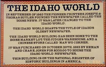
~Boise County~
Established February 4, 1864 with its county seat at Idaho City.
Named for the Boise
River, which was named by
French-Canadian explorers and trappers for the great variety of trees growing
along its banks. The Boise Basin, in which Idaho City
lies, was one of the richest gold mining districts in the nation after the
discovery of gold in 1862. At its peak in the 1860s and 1870s, Idaho City
was, for a time, the largest city in the northwest; it was this great influx of
people that lead to the establishment of the Idaho Territory.
Boise Basin
Mining District
)
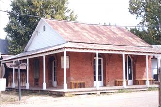
- In August of 1862, a party of prospectors from Florence discovered gold in
what is known as the Boise Basin; an area roughly twenty miles square, located
some thirty miles north of the current city of Boise.
The
gold was rich enough — $200 per day per man — that news started the Northwest’s
largest gold rush!
They came by the thousands, to Pioneer City
and Idaho City
(then known as Bannock City), to Placerville
and Centerville
and Granite Creek. (Note: Early mining in Boise Basin
were 6 to 8 walking hours apart. “That seems more a matter of geography than
planning”, says Kent Lambertson.)
When President Abraham Lincoln established Idaho Territory
in 1863, the Boise
Basin was the center of
the population, more than 15,000 strong. And Idaho
City was the center of the Boise Basin.
In fact, Idaho City
was the largest town in the Pacific Northwest, larger even than Portland, Oregon.
Gold
was the basis of everything in the Basin. Miners worked round the clock in
three shifts, trying to beat the day when the water would run out.
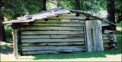
The
life of a miner was not easy. They had to deal with isolation, physical danger,
bad food, illness, and even death. Their tents and simple log cabins were all
that kept them warm and out of the severe elements of the cold winter months.
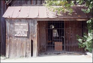
Pest House and County Jail located in
Idaho City
In Idaho City,
thirty-three whiskey shops lined the town’s 1 1/4 mile principal street. In
fact, whiskey was sometimes cheaper than water, since water was essential for
placer mining. but the town also had a veneer of
culture that gave it a fun loving atmosphere, with opera and theatre houses,
bowling alleys, music stores, tailor shops, and twenty three law officers.
The avenging angel visted Idaho City
not once, but twice. In May of 1865, most of the town and almost all of
the three hundred business establishments burned. Two years and one day later,
the town was once again left a smoking ruin.
But, unlike many Idaho
ghost towns, Idaho
City refused to die.
Merchants built brick buildings, with clay from nearby Elk Creek. They filled
the attics with dirt and fastened metal shutters to the doors and windows, all
attempts at permanence in a boom town setting.
Today,
Idaho City’s residents work and play in the shadow of nationally historic
landmarks, like the current museum, built in 1867 as a post office; the former
Miners Exchange Saloon, which now houses county offices; and the Boise County
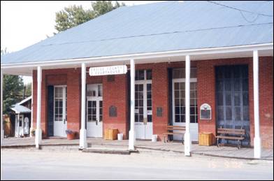
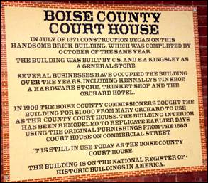
Court House, one of the state’s most important historic buildings.
Boise County
takes in the communities of Banks, Centerville,
Crouch, Garden Valley,
Gardena, Horseshoe Bend, Idaho City, Lowman, Pioneerville, and Placerville.
The Bogus Basin
ski area is in the southwestern part of the county. The county’s eastern area
contains the central section of the Sawtooth
Wilderness, the western part of the Sawtooth National
Recreation Area.
Banks
is located on Idaho State Highway 55 about 12 miles north-northeast of
Horseshoe Bend. As of the 2010 census, its population was 17.
The
North and South forks of the Payette River meet at Banks, which makes it a popular
destination for people rafting or kayaking on the Payette River.
The “Main” run of the Payette
River begins at Banks,
while the “Staircase” run on the South Fork ends at
Banks.
Centerville, or
what is now known as Old Centerville, was a mining community established in
1863 at roughly mid-point on a northwest/southeast axis between Placerville and Idaho
City. It’s
prime location on Grimes Creek served as a hub for miners moving north along
the creek to Pioneerville (originally known as Hog’em) and Grimes
Pass where gold had been
originally discovered in August, 1862.
Centerville
once boasted a population of about three thousand.
The last residents of Old Centerville moved out in about the late
1930’s, and the last remnants of surviving buildings were undermined and
destroyed in about the 1960’s.
A new road between Idaho
City and Placerville
was establised in the 1930’s replacing the original
track from Idaho City known as the “Spanish Fork” road.
The newer road along it’s present alignment bypassed Old Centerville; residents
established about two miles further south, near where the newer road -- now
known as Centerville Road -- crossed Grimes Creek, a vicinity which became
known as New Centerville. there never was any business
community in or around New Centerville.
Crouch
has an estimated population of around 154. The city was founded in 1934, and
named for resident William Crouch who was a homesteading miner near the Middle
and South Payette Rivers.
He donated property during the 1920’s for a hall in Garden Valley.
Crouch received its own post office in 1934. In 1933, an army came to town, Roosevelt’s Tree Army. Thousands participated in the
Civilian Conservation Corps from all over the country swamping the local Garden Valley
post office with letters for the boys. In 1934, a new post office opened for
Crouch to help the mail come closer to the CCC troops. The area’s economy was
helped by the workers during this depression era.
Garden
Valley mountain setting and recreation opportunities attract
visitors from the Boise
area. The life here in early American history, however, was harsh. Economic
opportunity was based on logging, mining, and ranching. In later years there
was work here as hunting guides.
Gardena,
located on the North Fork of the Payette
River, received its name
from Oregon Short Line Railroad officials in 1914. The name was possibly given
to make the area more appealing to future settlers.

Before Idaho
became a State in 1890, he built a winter cabin below Grandjean Peak on a site that later became
occupied by Grandjean Ranger Station. Because of his
European studies, he became a professional forester here. Then he served as
supervisor of Boise
National Forest from
1906-1922. Emile Grandjean
was one of Idaho’s
first forest rangers. Born in Copenhagen, Denmark in 1861, Emile immigrated to America in 1883, eventually settling in Idaho before it became a
state. Emile joined the Forest Service in
1905, and is credited for his early efforts in organizing many of the
conservation activities to protect the land from uncontrolled grazing and
mining. Today, Emile’s original forest ranger cabin is part of Sawtooth Lodge located on the south fork of the Payette River.

Horseshoe Bend was originally settled as a gold miners’ staging
area, as prospectors waited along the river for snows to thaw at the higher
elevations. Gold had been discovered in 1862 in the Boise
Basin mountains
to the east, near Idaho
City. The settlement
became known as Warrinersville, after a local sawmill
operator. The name was changed to Horseshoe Bend in 1867, and after the gold
rush quieted, the city became a prosperous ranching and logging community. The
railroad, from Emmett up to Long Valley following the Payette
River (its North
Fork above Banks), was completed in 1913.
Idaho City was founded
in December 1862 as “Bannock” (sometimes given as “West Bannock”), amidst the Boise
Basin gold rush during the Civil War,
the largest since the California
gold rush a dozen years earlier. Near the confluence of Elk and Mores Creeks,
its plentiful water supply allowed it to outgrow the other nearby camps in the
basin, such as Placerville, Pioneerville,
and Centerville.
As its population swelled, the new Idaho Territorial legislature changed the
town’s name to “Idaho City,” to avoid confusion with Bannack, Montana,
in present-day Beaverhead County, the southwestern corner of Montana.
At its
peak during the mid-1860s, there were more than 200 businesses in town,
including three dozen saloons and two dozen law offices. Its 1864 population of
7,000 made it the largest city in the Northwest, bigger than Portland. Wood was the prime source of both
shelter and heat, which caused Idaho
City to burn four times:
1865, 1867, 1868, and 1871.
In
1863, St. Joseph’s Catholic Church was
established; it was the first Catholic parish in the new Idaho Territory
and the church was completed the following year.
Idaho
City is an important
location in local Masonic history. The Grand Lodge of Idaho was founded in Idaho City
in 1867. Idaho Lodge No. 1 was originally located in Idaho
City, but is now in Boise.
During the boom, the greater Boise Basin
population numbered in the tens of thousands, but most departed the mountains
once mining declined. Idaho
City’s population fell
below 900 by 1870 and was down to 104 by 1920. The modern economy relies mainly
on hunting and fishing tourism, and visits to the many historic sites,
including the Boot
Hill Cemetery.
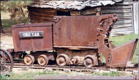
Outside of town, the mining tailings of the era are ubiquitous.
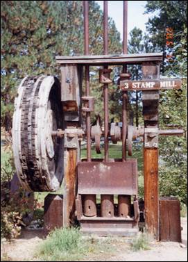
3-Stamp
Mill
A
stamp mill is a type of mill machine that crushes material by pounding rather
than grinding, either for future processing or for extraction of metallic ores.
Breaking material down is a type of unit operation. A stamp mill consists of a
set of heavy steel (iron-shod wood in some cases) stamps, loosely held
vertically in a frame, in which the stamps can slide up and down. They are
lifted by cams on a horizontal rotating shaft. As the cam moves from under the
stamp, the stamp falls onto the ore below, crushing the rock, and the lifting
process is repeated at the next pass of the cam. Each one frame and stamp set
is sometimes called a “battery” or, confusingly, a “stamp” and mills are
sometimes categorized by how many stamps they have, i.e. a 10 stamp mill has 10
sets.
Senator Frank Church announced his candidacy
for the Democratic nomination for president from the porch of the county court
house in Idaho City in March 1976. His grandfather had
settled there in 1871 and his father was born there in 1889. Chase Clark,
Church’s father-in-law, had announced his candidacy for governor in Idaho City
in 1940.
Four
thousand Chinese lived in the Idaho
Territory from 1869 to
1875. Like many Chinese immigrants, they came to “Gold Mountain”
to work as miners, or found work as laundrymen and cooks. The store of Pon Yam, a prominent Chinese businessman Pon Yam House from 1867 is one of the only remaining
buildings from Idaho
City’s Chinese. Although
today Chinese are rarely seen except as tourists, the 1870 census reported at
1,751 Chinese who were nearly half of city residents. Annie Lee was one
legendary Idaho
city woman who like Polly Bemis, escaped enslavement from the “world’s oldest
profession”. She escaped from a member of the Yeong Wo Company in the 1870s to Boise to marry her lover,
another Chinese man. Charged by her owner with grand larceny, she told a judge
that she wanted to stay in Boise
City. The judge
subsequently granted her freedom.
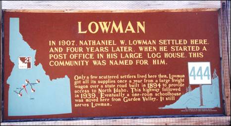
Lowman
is named for the homesteader Nathaniel Winfield Lowman from Polk County, Iowa.
It is nestled along the banks of the South Fork of the Payette
River at the junction of State Highway
21, eighty miles from Boise
and what will formerly be known as the “Banks-Lowman Highway”. It is the
“Wildlife Canyon Scenic Byway.”
The
small community of Lowman is settled in a geothermal active region. Natural hot springs surface in the
middle of the community as well as in many other places in the surrounding
mountains. As of the 2010 census, its population was 42.
Pioneerville had
the first post office in the Boise
Basin and a population of
over two thousand.
Placerville
received its name because of placer mining in the vicinity. The ghost town is
located 17 miles east of Horseshoe Bend. The townsite
was selected December 1, 1862; and by December 16 there were six cabins in the
camp. By the early summer of 1863, the town had 300 buildings and a population
of 5,000. At the meeting of the first legislature held in Lewiston in 1863, the citizens obtained a
charter for their city. Father Mesplie, a Catholic
priest, held the first church service January 4, 1864, and in that same year a
stage line was established between the Basin and Wallua
to carry Wells Fargo express. It ran every other day from Placerville and went through in four days. By
July 1864, 4500 claims had been recorded in that district.
Unlike the earlier northern Idaho mining
areas of Florence (northeast of Riggins) and Pierce, the Boise Basin mines
provided good returns over a period of many years, the peak years being
1863-66, during and immediately after the Civil War. For that reason the Boise Basin
rush was significant in early Idaho
settlement, bringing a substantial number of people who stayed to establish
towns and providing a population base for retailing and agricultural settlement
in the Boise Valley. Boise
Basin had a higher percentage of
families than did most mining areas, and the major towns, like Placerville
and Idaho City, acquired substantial buildings,
lodges, churches, schools, and post offices. Placerville was unusual in that it even had a
street grid and a town square, known locally as the "plaza."
Additionally it had an Episcopal church, thirteen saloons, seven restaurants,
five butcher shops, five blacksmith shops, as well as hotels, druggists,
express agents, bakeries, livery barns, carpenters, sawmills, and –attesting to
the presence of women—dressmakers and a millinery shop.
Mining in Placerville began with placer workings for
gold, but miners soon turned to quartz mining as well. By 1864, a stamp mill
was working in the area. Hydraulic giants were also used. By 1870, however,
much of the excess population of the region had been drained off to other
mining rushes and returns on claims had fallen somewhat. The population in Placerville shrank from
2500 in 1864 to 318 in 1870. By that time a good percentage of the population
was Chinese, as the Chinese were allowed to work the less rewarding claims that
the white miners would not touch. The Chinese also established services like
laundries and restaurants.
Only few early buildings remain in Placerville: as was the case in most mining towns, Placerville suffered more
than once from fires that burned a large part of the town. The fire that is
most remembered is the 1899 fire, which practically destroyed the town. The
streetscape remaining today dates mostly from the rebuilding immediately after
that fire and another fire that burned several buildings ten months later.
During the war years Placerville just maintained like the rest of
the nation. Wartime restrictions included a suspension of the mining industry.
There was no growth — only a feeling of "things have to get better."
In the early 1970s the upper lots were
auctioned off creating what was and are now known as the "upper
subdivision." There were both permanent and vacation homes built on these
lots. Then as now there was only one business in Placerville, the city store.
Placerville
continues to survive with the few full time residents, some part time
residents, the Village Market store and the tourism industry which includes
among others, history seekers, hunters and ATV and snowmobile recreationalists.
The incorporated city is governed by a mayor and city council which meets
regularly at City Hall. The city is served by the Placerville Fire Department
which has its fire station located adjacent to the city plaza and the East Boise
County ambulance service.
There are two city museums which are maintained by public donation and
volunteers and are open weekends from Memorial Day to Labor Day and by special
request.
In 1984, the settled areas of the city were
listed on the National Register of Historic Places as a historic district, the
"Placerville Historic District."
Please check out Hi-Liting
Idaho on our website: www.elmorecountypress.com
Idaho City Chamber of
Commerce
Idaho
City Historic Information)
Source:
Kent S. Lamberson, Oscar Baumhoff,
Wikipedia, Boise County,
Blaine County, Idaho Public Broadcasting, & misc.